


The Week’s Weather up to Friday 20 October. Five-day outlook to Wednesday 25 October 2017
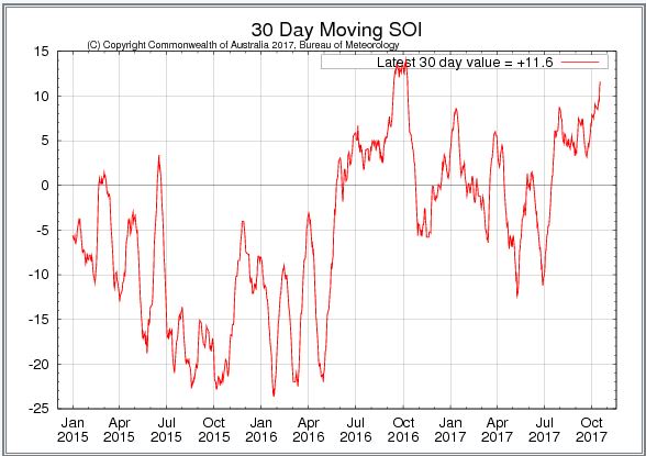
Graph. Southern Oscillation Index maintained by the Australian Bureau of Meteorology.
The graph tracks the relative difference in surface barometric pressure between Tahiti in the Pacific and Darwin in North-east Australia. The two places are about 1000 km apart. The daily relative values are compared to the readings of a month earlier to derive at a moving daily index value. Values greater than +8 are deemed to indicate La Nina conditions while values less than -8 indicate El Nino conditions. (Published by namibiaweather.info)
There is a very strong, empirical correlation between the Aussie’s Southern Oscillation Index and rainfall conditions in the south-western quadrant of the southern African subcontinent. This has not been adequately explained by meteorologists but it remains a fact that when the eastern Pacific is cooler, the Indian Ocean Transport is enhanced, and the route of continental advection then runs prominently across southern Tanzania, northern Mozambique, Zambia, the southern DRC, Angola, and from there into Namibia and Botswana.
This week the index jumped from last week’s +7 to +11.6 . This does not mean the index will remain positive but compare the pattern of September and October this year to August and September 2016 and it shows the same broader movements.
Rainfall conditions were extremely negative last year up to around June. This coincided with one of Namibia’s worst droughts. During June, the index turned positive albeit still below +7 where it lingered for July and August. Then the curve moved rapidly up in September and despite plunging back in October, it was back in positive territory by December 2016. From January to May it gyrated between negative and positive giving Namibia a reasonably good rain season that carried on relatively late into May.
This week’s move in the index may just be a portend that a similar pattern as last year is emerging. Coupled with the observed cooling in the eastern Pacific, rainfall expectations, at this stage, are still for an average to above average season.
Locally, this week was marked by another cold intrusion from the South Atlantic high pressure cell. Its presence became noticeable from Monday evening continuing to have an impact on night time temperatures as far north as Windhoek. The overall synoptic pattern still showed a late-winter bias with the cores of both the South Atlantic and southern Indian high displaced to the north by some 600 kms.
It is however, the ocean south of the continent where the strongest activity occurs and this week was no exception. Enhanced low pressure systems with strong vortices at their southern extremities have been the signature of the past two month. This is still continuing.
So while this week saw a succession of weak cold fronts, the low pressure activity to their south drains them away from the continent hence the very brief cold intrusions. And while the two high pressure cells are of normal strength, they quickly collapse once over land, so the warmer air from the north rapidly replaces the cold air from the south.
It is also now the period after the solstice where total daily duration of sunshine exceeds the cooling phase during the night. It is only natural to expect that the tropical northern conditions will have a growing impact.
This was also displayed by this week’s weather where almost wintery conditions in the Karas Region were offset by extremely hot days in the Kavango, Bwabwata and the Caprivi. This heat is the result of the so-called heat-low which forms over the central plains of the sub-continent where Angola, Zambia, Namibia, Zimbabwe and Botswana meet. It is a typical occurrence early in summer and will grow stronger, and hotter, by the week, until relieved by the first large-scale intrusions of moisture from Zambia and Angola.
What’s Coming
The two high pressure cells remain in situ for the weekend with only a limited intrusion over eastern South Africa. Lower pressures are present over the Namibian and Botswana interiors with windy conditions in the late afternoon. The closer to the escarpment, the windier it will be.
The South Atlantic high is not expected to make landfall meaning Namibian weather will be determined mostly by what is happening to the north. It spells a continuation of hot to very hot days for the entire country.
The heat-low over the Caprivi is absent on Monday and Tuesday but it forms again on Wednesday.
Due to the anti-cyclonic circulation over the sub-continent, some moisture should be advected from Angola into the interior, also from Monday to Wednesday. Considerable cloud cover is indicated but at elevations above 14,000 feet thus not indicative of rain. Light rain is however indicated for the northern and north-eastern quadrant.
By Wednesday evening, a weak cold front passes south of Cape Agulhas but the only local impact will be windy conditions over the southern Namib.


