


The Week’s Weather up to Friday 14 July Five-day outlook to Wednesday 19 July
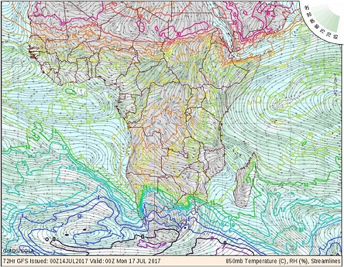
Map: Wind direction, temperature and relative humidity near surface (ground) level on the interior plateau (850mB) for Sunday 16 July 2017. The map is relevant for the 12-hour period preceding the time marker at the bottom of the image which indicates midnight Sunday/Monday.
Source: wxmaps.org, GrADS/COLA
The dominant feature of the week’s weather is the extensive ridging in the upper air, covering most of Namibia and in fact, very large areas of southern Africa. Ridging indicates upper air high pressure control originating from the strong high pressure conditions prevalent on the surface over the eastern half of the sub-continent.
Whenever the upper air is controlled by high pressure conditions, the air is of a higher density and a lower temperature than the atmosphere in the adjacent areas. This is not restricted to district or regional level, instead it often covers a whole country, or even a whole section of a continent.
At the beginning of the week, the South Atlantic high pressure cell has just made landfall south of Oranjemund. As the week progressed, the high slowly migrated across South Africa from west to east, eventually settling over eastern South Africa from where it impacted the rest of the sub-continent’s weather. High pressure cells are by nature and by definition like very large, extensive bubbles on the surface that may cover several thousand kilometres. At their cores they are cold, dense and stable. Since they are so massive, their influence lasts several days.
As the high settled over the sub-continent, it is heated by solar radiation. By day from the sun above and by night from the radiation that escapes from the earth’s surface. This infusion of energy eventually weakens the high, and as it departs to the east, it may simply disappear or be displaced by low pressure systems from the north. However, the high’s after effects linger in the middle and upper layers of the atmosphere, and exerts an influence long after the core has departed.
By definition, highs are denser pockets of air, but from around 15,000 feet upwards, this becomes a very relative measurement since the atmosphere, at that level and above, is thin and cold. But because of its immense size, the high remains in the upper air creating stable conditions on the surface.
During this week, while there was ample humidity in the lower and middle levels, cloud formation was sporadic and restricted to specific layers. This is because the high pushes down from above. Similarly, while the nights are cold due to the direct impact from the south, the temperature quickly rises during the day as the bigger part of the energy stays captive on the surface due to the restrictive high pressure conditions above. In the afternoon as the solar energy abates, the high tends to sink again, compressing, releasing energy and causing pleasantly warm afternoons. These movements are not large, maybe only a thousand or so metres in vertical extent but because the system is so massive, it dominates all other weather aspects.
With the exception of the southern Namib, the Karas Region and the Kalahari along the Botswana border earlier in the week, the rest of Namibia had an unseasonally warm week with daytime temperatures in many places reaching 29°C.
What’s Coming
By Friday, a major cold front lies about 200 km offshore Cape Town. This is expected to make landfall during Saturday with night time temperatures dropping. Sunday will also be a cooler day and Sunday night will be cold.
As can be seen from the map, the surface temperature is expected to be below zero over large areas of the Western Cape and the southern Cape.
However, ridging continues over Namiba and by Monday, the cold intrusion will start receding in strength. The map also indicates that only the eastern half of the Karasburg district will be really cold but similar to this week, if the upper air conditions persist, frost is unlikely.
A cool Monday is forecast for the interior east of the Fish River Grootfontein line. As is typicaly, by Tuesday, the northern and western half of the country should be warmer already with only the eastern parts of Otjozondjupa, Omaheke, the Keetmanshoop and Karasburg districts still feeling the cold on Tuesday.
By Wednesday the surface airflow will have reverted to north-east, again indicating warmer days.
A large pressure differential between the interior and the coastal plain is present during Monday, Tuesday and Wednesday. This may lead to strong Oosweer from around St Francis Bay further north. The northern Namib may experience severe sandstorms with the highest intensity on Wednesday.


