


How cold will this winter be?
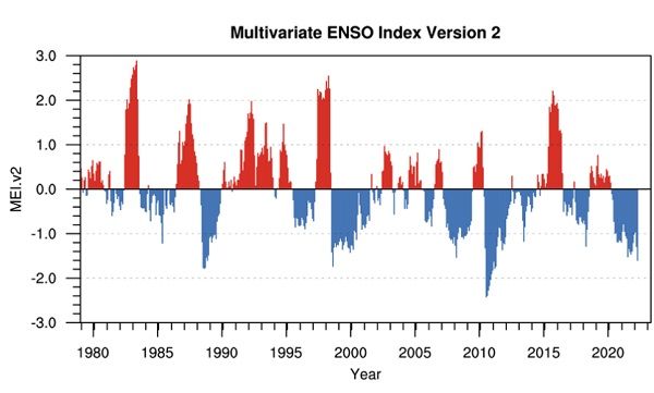
Visual: Multivariate ENSO Index Version 2
Source: Physical Sciences Laboratory of the US Government’s National Oceanic and Atmospheric Administration. https://psl.noaa.gov/enso/mei/ .
Overview
The second cold spell of the winter presented a classic approach, impact, depart pattern of the South Atlantic high pressure cell as it made landfall on Tuesday with very windy conditions at the coast.
This produced some astonishing sandstorms with many images circulating on social media to show the condition of the road between Walvis Bay and Swakopmund. Although far less people travelled to and from Lüderitz, conditions there were very similar, only the wind was somewhat stronger with considerably more sand on the road.
By Wednesday the south-westerly wind has veered to the south and although the interior experienced a mild day, the windchill factor was elevated. It was a really cold wind.
As was expected, on Thursday the wind has turned east but was still very cold while temperatures in the interior dropped markedly following the penetration of cold air the previous day. But as is the typical Namibian winter cold spell, the easterly wind was still very cold, continuing the fresh conditions on Friday.
The reason why the successive weather events of the week is important, is because they show the strength and impact of the South Atlantic high pressure cell that moves from west to east in a regular 4-days on 4-days off pattern. This high pressure cell is the most important feature of the Namibian weather scene and while it very seldom makes actual landfall in Namibia like in the Western Cape, its control over the middle and alto levels of the atmosphere is almost absolute. To understand this in context: – the South Atlantic high is the cause of the Namib desert and since this is an ancient geographic feature, it shows that the high has been around for hundreds of thousands of years.
We also get an idea of the force of the South Atlantic high during summer when it forms active convergence zones with the anti-cyclonic atmospheric circulation from the tropics. These convergence zones are usually situated over Namibia and can readily be observed from the surface. The dynamic interaction between tropical and Atlantic air is what drives the rain season.
But it is in winter when the South Atlantic high shows its real muscle. When approaching the coastline along the southern Namib, it pushes heavy winds northward along the shore, causing sandstorm and wet foggy conditions in the coastal towns.
And it is also during winter that it shows it regularity. It takes about four days to approach the continent, then it takes about four days from landfall to departure. This part is a typical cold spell and it advects cold Antarctic air from the far southern seas to the African continent. This is followed by another four mild, quiet days before the whole cycle repeats itself.
Since we are only at the beginning of the winter, the coldspells are still mild and while there was some expectation for zero degrees in the south and east, it did not produce frost. It is only later in winter, from the second week of July, that the coldspells are more intense and the penetrating air well below zero.
Many people now ask whether this is going to be an intense winter since it started relatively early. The answer is that cold weather in May is not unknown but the biggest difference between this 2022 winter so far and the preceding two winters (2021 and 2020) is that it arrived gradually with a clear transition from late summer to early winter. The previous two winters were both marked by summer conditions the one week, and very cold conditions only a week later. So far, we have not had such a dramatic switch.
The consolation is that although it may be bitterly cold for a few days, it is always followed by a four-day warmer spell. Being a fairly regular winter so far, it is reasonable to expect that the 4-days-on 4-days-off pattern will continue for June and July.
Finally, the visual shows that global weather is still very much in a La Nina pattern which is an indication of a milder but longer winter in Namibia and generally favourable expectations for the next rain season.


