


Weekly overview and short-term outlook to Wednesday 12 June 2019
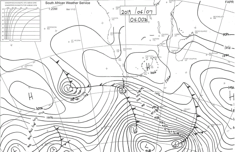
Visual: Synoptic Map for southern Africa as at Friday morning, 07 June.
Source: South African Weather Service, www.weathersa.co.za/images/data/specialised/ma_sy.gif .
Recent Developments
Local weather is about as quiet and as static as one can get.
The continental high pressure cell that covers southern Africa in the visual, is the former South Atlantic high that has moved from a position west of Cape Town at the beginning of the week, to where it now sits.
Ahead of this cell was a frontal system, fairly strong at first, but receding as it made landfall and eventually by the end of the week, pushed to the south-east to a position due south of Madagascar.
Note also that the continental high now effectively blocks the second cold front to its south, preventing significantly colder air from reaching Namibia.
For the duration of the week, the synoptic progression showed a standard winter stance. The South Atlantic high did its migration from west to east, making landfall in the Western Cape early in the week, bringing some light and widespread rain.
The southern Indian high sat south of Madagascar, with a strong attack on the Malagasy east coast. Over southern Africa, the typical anti-cyclonic circulation was active with a weak mid-level trough on its western side, i.e. over Namibia, but with little or zero moisture advection.
The slightly colder nights of earlier in the week were replaced by warmer temperatures on Thursday and Friday, but it was not nearly a mid-winter occurrence.
All in all, a very typical early winter week with very little movement other than the persistent eastwind conditions over the central and northern Namib due to the anti-cyclonic circulation.
Notable however, was the relatively cold weather along the entire length of the coastline. This was the result of the South Atlantic high blowing onshore, as it migrated around the Cape of Good Hope. But even this effect was limited to only about 20 km inland from the shore.
Travellers from the coast to the interior noticed this, remarking how cold the weather at the coast was, but only about 30 km outside Swakopmund, the desert temperature exceeded 30°C.
For the entire Namibia, it was clear skies, warm to hot days, very little wind, and cool nights. As uneventful as one can imagine.
On the Radar
Static early winter conditions continue over the weekend and into next week. The only disturbance is some instability at the 500 mB level (18,000 feet) over the Karas region that should become visible during Sunday afternoon as high level cirrus clouds.
On the surface the impact will be very small other than a fresh southwesterly wind in Oranjemund and Lüderitz.
The wind over the interior will remain easterly leading again to Oosweer conditions over the central and northern Namib but as with this week, the approaching South Atlantic high will block its advance about 20 km away from the coastline itself.
The pressure differential gradually subsides and by next week only the northern Namib will be affected.
Conditions in the south will change fairly drastically in the Karas and Hardap regions by next Wednesday afternoon when the next high has moved across land, bringing cold, dense air to the southern half of Namibia.


