


Overview for the week and 5-day outlook to Wednesday 17 January 2018
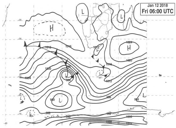
Visual: Synoptic Map as at Friday 12 January 2018
Source: South African Weather Service
http://www.1stweather.com/maps_fx.php
What Happened
The El Nino Southern Oscillation index of the Australian Bureau of Meteorology has turned starkly negative over the first two weeks of 2018. This is not a good sign unless it bounces back within the next two weeks. At the middle of December it was still a healthy 12.5 index points but it started plummeting shortly thereafter reaching zero between Christmas and New Year, and it has kept going down since. By the end of this week, it read -4.5 .
The synoptic map above provides a usefull summary of weather events as it transpired during the week. On a broader scale it shows a fairly regular synopsis of elements. The southern Indian high is located in its customary position south-east of Madagascar with its signature influence over the eastern parts of South Africa. There is a low pressure tropical intrusion over northern Namibia with generally lower pressure over the western half of the sub-continent.
The negative aspect, however, is the relative strength and the position of the South Atlantic high pressure cell. For the duration of the week, it was stuck offshore Namibia with its core more or less on the same latitude as Lüderitz. This means the core is displaced to the north by a good 500 km. Its usual position should be about 1000 kilometre offshore Saldanah Bay. Although the core reads only 1020 mB, when it moves south to travel around the southern Cape, it strengthens to 1024 mB, which is normal.
It is this northward displacement of the South Atlantic high pressure cell that has inhibited local rainfall in Namibia so far this season. Its impact is felt on a daily basis when so-called ridging in the upper air, compresses the air near the ground, causing heatwave conditions which have been prevalent over the southern half of Namibia, the Northern Cape and the Western Cape since New Year.
Although the consensus outlook for the season leans heavily on conditions in the Pacific where a strong La Nina is present in the eastern Pacific, local conditions are not that positive. At best, they are “normal” but to date the expectation for “above normal” has not shown up yet.
Other negative aspects include a neutral Indian Ocean Dipole, a weak Indian Ocean Transport, and a fragmented atmosphere over East Africa. Although the Indian Ocean Dipole, the difference between sea surface temperatures south of Indonesia and east of Tanzania, is gradually shifting, this movement may be so slow that its impact will only materialise after our main rain months.
Perhaps the only short-term positive development is the position of the southern boundary of the Inter-Tropical Convergence Zone.
In the second half of the austral summer after the Sonnewendung on 21/22 December, it is normal for this convergence zone to move into a position south of the equator. Over the oceans, in our case the Gulf of Guinea in the west and the Indian Ocean in the east, the convergence zone is relatively narrow, seldom extending over more than 10 degrees latitude. But over the continents, Africa, South America and Australia, it pushes far to the south, close to about 20° South. In other words, amplified by the solar energy over land, it can move about 1200 kilometre further south over land than over water.
Over the past two weeks, the zone’s southern boundary has moved visibly by the day from about 600 km into Angola, where it lingered for a while, to smack on the Owamboland Angola border. This is very positive although slightly late in the season.
When the Inter-Tropical Convergence Zone hugs the Namibia Angola border, and when it runs continuously through the continent to the Mozambican Channel, it is an indication that the Indian Ocean Transport is growing stronger. This indeed has been the case over the past two weeks.
What’s Coming
Ridging over the southern half of Namibia continues for the next five days indicating that the afternoons will be extremely hot. There is however much upper air movement over the northern half.
Futhermore, driven by the anti-cyclonic air circulation over the sub-continent, the dominant airflow over Namibia will remain north-east to north.
Much moisture is in circulation and strong cloud formation should take place on a daily basis. Thus, rainfall conditions over the northern half and north-eastern quadrant are reasonably positive.
Although cloud banks should penetrate the interior up to the escarpment on a daily basis, upper air conditions over the southern half are not conducive for rainfall and only the lucky spot here and there can expect brief thunder showers.
Overall, rainfall conditions are inhibited by the proximity of the South Atlantic high pressure cell and total precipitation will remain disappointingly low. It is only by Tuesday next week when there is a marked shift in conditions at which point there is opportunity for widespread light rain over most of the country except the Kalahari south of Gochas.
The bias will be over the north-eastern quadrant and over the western half along the escarpment.


