


The Week’s Weather up to Friday 01 September. Five-day outlook to Wednesday 06 September 2017
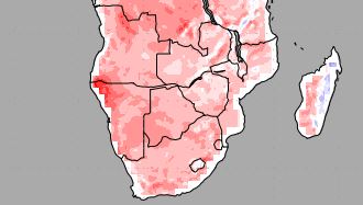
Map: Mean Surface Temperature Anomalies for Southern Africa from 01 Sept to 09 Sept 2017.
Source: Temperature Forecasts from the National Centers for Environmental Prediction.
GrAds/COLA.
This was another week where the two high pressure cells on either side of the sub-continent failed to have a significant impact on land while the low pressure system south of Cape Agulhas, and between the two highs, had a much bigger impact to the north.
Since the low pressure system developed behind the trailing rim of the southern Indian high, it was characterised by a pronounced north to south airflow, leading to warm to hot days in Namibia.
By midweek the next approaching South Atlantic high made landfall spreading slowly across South Africa from west to east. However, its influence was restricted mostly to the area south of the Orange River so the local impact was much subdued other than the expected nighttime cooling.
By far the biggest impact on regional weather came from an extremely strong vortex, reading only 948 mB at its core, more than 4000 km south of Cape Town. Inconceivable as it may sound, this vortex sitting south of the South Atlantic high, drains the high away to the south. This was readily observed on the daily synoptic maps as the high extended a southward bulge which reached further south by the day.
This weakening of the high pressure cells on their leading rims (east) followed by dissipation to the south, has been the hallmark of this past winter. The mild winter over much of the subcontinent was the result. The highs, as they migrated across South Africa, never had opportunity to develop their full impact, being sucked away to the south instead of blowing up (northward) the Mozambican Channel.
The temperature forecast map above for the next eight days shows unmistakeably the impact over Namibia. Not only was the entire winter unseasonally warm, it is continuing into spring with mean temperatures higher by between 4 and 6°C. Not a single place in Namibia has reported frost over the past four months.
The enhanced vorticity in the southern ocean has also dimished the northward reach of cold fronts. While frontal activity was plentiful, the north to south airflow behind a front only reached full strength on a few occasions and then the impact was restricted to the higher elevations in South Africa.
By the end of the week, the high has covered much of South Africa but its impact over the central Kalahari remains weak and the sunshine hours per day, as well as the sun’s angle, is increasing steadily.
What’s coming
The first indications of the familiar yin-yan pressure pattern appears over the weekend. This pattern is seen on the synoptic map when there is a considerable difference in barometric pressure along the coastal plain below the escarpment compared to the interior above the escarpment.
A system of lower pressure develops from the Angola Namibia border extending over the North and moving down the western half up to the Orange River. This indicates hot conditions in the North and the north-west as corroborated by the temperature anomaly forecast above.
By Sunday afternoon the low pressure system has reached the southern Namib and strong winds with sandstorm can be expected between Lüderitz and Oranjemund.
By Monday, much of the ridging in the middle levels which have been observed during mid-winter makes room for more unstable air with a marked north to south airflow. This advects some moisture from Angola.
By Monday, the continental high over South Africa has departed and the weak low pressure system is expected to develop into a more pronounced trough.
This will amplify the north to south airflow from Angola across the Namibian interior into South Africa. The trough moves to the east and by Tuesday, mid-level clouds are expected to be visible over the northern half.
For Tuesday, two forecasts indicate very light precipitation in the form of drops but two show none. The most rational expectation is for some light rain in the middle to upper levels with very little, if any, reaching the ground.
By Wednesday conditions return to an early summer, stable pattern but with lower pressures lingering in the north, it will remain hot in the north and north-eastern quadrant.


