


The Week’s Weather up to Friday 02 June Five-day outlook to Wednesday 07 June

Precipitation Forecast for Wednesday 07 June 2017
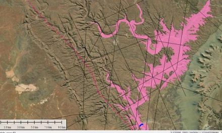
Source: wxmaps.org, GrADS/COLA
The relevant map for the weather discussion is the rainfall forecast for next Wednesday. It shows a strong low pressure system area ahead of an approaching frontal system with an extension into Namibia’s Sperrgebiet. These surface conditions are mirrored by mid-level developments indicating that the coming frontal system will have a considerably vertical depth, possibly extending as high as 25,000 feet up. This is not typical for the Western Cape winter.
The synoptic development during this week corrobarates the expectation for improved rainfall over South Africa’s winter rainfall area, with possible and frequent northward extensions to the Orange River valley.
At the beginning of the week, the South Atlantic high pressure cell has just made landfall north of Cape Town. As the week progress, the high’s core shifted along the southern Cape coast and then spread into the South African interior. In Namibia, however, the surface windflow remained consistently north-east to north, quickly displacing the brief cold intrusion of Monday night. At the high’s core, conditions were very cold but the usual intrusion into eastern Namibia across Botswana was restricted by the northern airflow from Zambia and Angola southward across the Namibian interior.
The weather stance has now developed into a marked contradiction between conditions south of the Orange River and north of the Namibia Angola border. While the southern half of the sub-continent is unmistakeably in a winter stance, the airflow over Mozambique, Zambia and Angola is still controlled by a late-summer pattern. The three countries between these two zones, Namibia, Botswana and Zimbabwe are exposed to the typical late-summer see-saw weather when the interplay between winter from the south and a lingering summer from the north, leads to rapid changes, even on a 24-hour basis. It also creates considerable variance between temperatures over the Karas and Hardap region, and the northern regions.
By the end of this week, most of the sub-continent was under high pressure control on the surface. The map at the top, altough only for next Wednesday, clearly shows the expectation that high pressure conditions will control the weather as far north as the equator, bringing to southern Africa the dryness of winter, except in the Cape’s winter rainfall area.
The important development during the early-winter phase is the anomalously large distances between the high pressure cores around the southern hemisphere. This makes room for low pressure systems to develop in the spaces between the high pressure cells, creating a stronger than usual north-south-north airflow. It is also the reason why the cold front of the previous weekend had such little impact over Namibia.
On Friday, most of Namibia east of the escarpment had pressure readings around 1020 mB in the early morning with lower pressures along the coastal plain but the differential during the week was slight, meaning an absence of Oosweer. The only exception to a typical winter stance is the consistent north to south airflow over the Namibian interior, a result of the prominent low pressure systems filling the gaps between the high pressure cells.
What’s Coming
For the duration of the weekend, southern Africa remains under high pressure control indicating clear skies and sunny days. Surface airflow is anti-cyclonic with an approaching cold front about two days out to the west. The strong anti-cyclonic circulation creates a weak convergence zone but at elevated levels, i.e. above 18,000 feet. This may bring in a thin line of cirrus cloud stretching from Walvis Bay across southern Namibia up to Mata Mata and extending into Botswana and northern South Africa. This convergence zone, given its elevation, is not the reason for the expected light precipitation in the southern Namib but will only be visible as thin winter clouds.
On Monday and Tuesday, a cold front approaches the Cape, possibly making landfall on Tuesday night although the forecast maps are not in agreement on this development. With the interior of South Africa still under high pressure control, next week will see another intrusion of cold coming across Botswana from the east.
The feature to watch is the expected precipitation over the southern Namib. If during the winter, the cores of the high pressure cells remain far from one another, it will improve the odds for strong frontal systems to develop, consequently improving conditions for rainfall in the winter rainfall area.


