


The Week’s Weather up to Friday 12 May Five-day outlook to Wednesday 17 May
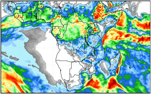
Precipitation forecast from Friday 12 May to Friday 19 May 2017
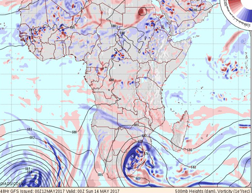
500 mB lateral advection forecast for Saturday 13 May 2017
Source: wxmaps.org, GrADS/COLA
The two maps selected for this week’s discussion of local weather, cover the precipitation outlook for the next eight days while the second map shows atmospheric conditions at approximately 18,000 feet elevation.
The first map merely shows that Southern Africa is now in an early winter stance with Namibia, the South African interior and most of Angola now firmly under high pressure control. This map also shows that the southern boundary of the Inter-tropical Convergence Zon is still well-defined, and now lies a few hundred kilometres north of Madagascar. In the western side, it is more or less on the northern Angolan border indicating that it has shifted roughly 1000 km since the beginning of March.
The second map is much more revealing. These are the expected conditions at the so-called 500 mB surface, roughly 18,000 feet aloft. Since the atmosphere is not layered or strictly separated, 500 mB maps are representative of conditions from about 10,000 feet to 25,000 feet elevation. This is the rainmaking zone, so whatever happens in this layer of the atmosphere, has a direct bearing on the amount of precipitation produced in a specific area. Given the season, much of this precipitation will be in the form of snow and not necessarily rain.
In the 500 mB map, the blue areas are lines of unstable air with enhanced lateral movement. The pink areas are so-called rigdes, indicating quiet, stable columns of air. The Saturday forecast was chosen randomly.
It shows that the most intense activity is located over the eastern half of South Africa. This is also where the highest rainfall and snow will occur. The flat pink areas show ridging over the western half of South Africa, Botswana and most of Namibia south of Grootfontein. Definitely not conducive for rain in these areas. But notice the light blue bands over northern and north-western Namibia, indicating that the atmosphere over this area will be less stable. However, at this time of the season it will probably only produce cirrus clouds. In the left corner, the map shows the next approaching frontal system which is what will bring the rain to the Western and southern Cape, indicated in the first map. This will take about 3 days to reach land.
Going by the 500 mB map, the logical conclusion is that the rain season is over. But the maps for this week looked very similar, still on Tuesday and Wednesday substantial rainfall was reported in a narrow south to north band from the Okahandja district through Otjiwarongo and up to the Grootfontein district. Isolated showers were also reported in some of the central western districts.
This happens in the so-called convergence zone where the high pressure from the south-west and the south undercuts the inflow of moisture from the north-east and north. Over the interior it raised the cloud base to around 12,000 feet but there was ample inflow of moisture from Zambia to produce clouds. While the sunshine hours still exceeds 11 hours per day, it provided sufficient energy for good convergence, producing the strong showers late Wednesday afternoon.
What’s Coming
This Friday, a strong high pressure cell lies due south of Cape Agulhas with a core reading of 1034 mB. The 1024 mB isobar reaches to the Orange River indicating that the Karasburg district will be very cold. Cool morning will be felt along the Botswana border as far north as Tsumkwe with the colder air coming from the east.
The next frontal system is about 3 days out over the South Atlantic. This front lies between the high south of the continent and the next approaching high. Ahead of the front, the airflow will be prominently north to south with warmer conditions over the western half of Namibia, while behind the front the airflow will be south to north, bringing in much colder air from the southern ocean. This should arrive around Monday night.
Mild Oosweer along the entire coastal plain will continue until the arrival of the front.


