14 November 2014
![]() What Happened?
What Happened?
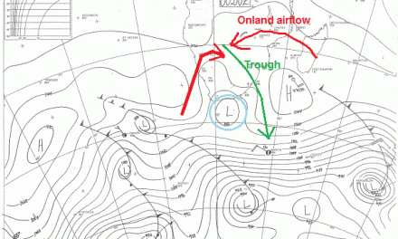
The week started with a very regular synoptic pattern. The South Atlantic high pressure cell had its core some 4000 km offshore west of the continent while the Southern Indian high pressure cell sat about 2500 km south-east of Madagascar. Between the two highs but at a somewhat more southern position, a prominent vortex (low pressure core) hovered 1000 km south of the southern Cape. From Angola to South Africa, crossing Namibia from the north-west to the south-east, ran the customary trough (broad low pressure band) in the middle levels more or less from 15,000 feet to 30,000 feet above sea level. This trough is the channel for moisture from the tropics and it caused widespread rains in Owamboland, and the two Kavangoes on Sunday and Monday. Pockets of moisture also penetrated further south as can be seen from the rainfall in the eastern half of the country, all the way south to the Kalahari.The duration of the trough was however very brief and the cloud base remained above 16,000 feet for most of the time, but at those locations where it descended, higher rainfall was recorded. Earlier in the week, several farms in the Okahandja, Otjiwarongo and Tsumeb districts reported falls approaching 50 mm. The rainfall in Windhoek on Tuesday afternoon provides a very good example of how isolated good falls can develop if conditions are right. Satellite images show that the cloud formation was very localised. Only west and south-west of Windhoek a few cloud tops reached into the 200 mB stratum at about 36,000 feet. At the same time, the cloud base rapidly descended from 18,000 feet to 7000 feet. The result was that Windhoekers were pleasantly surprised with rainfall across the city and the commons reading between 10 and 12 mm. This same pattern was repeated in several place from the north to the south-east, and all these places recorded not insubstantial falls, but all very brief despite the intensity. By Wednesday, this trough has shifted towards the east, pushed from the west by the now-approaching South Atlantic high. Thursday morning saw a much colder south, and the chilly morning was felt as far north as Okahandja. The windflow was south. The northern half of the country remained warm to hot with airflow from the north-east, and as the trough moved towards Botswana, rainfall remained restricted to Kavango East, the Zambezi, and Otjozondupa East.
This Friday morning proved to be even colder especially in the eastern zone of Karas and Hardap.
Rainfall for the week
10 Nov: Gobabis 30.6; Goedemoed 21; Mpacha Airport 9.8; Oshikango 9.2; Okongo 9; Rundu Airport 8; Rundu 7.8; Ondangwa 7; Otjiwarongo 6.6; Aranos 3.2; Okaukuejo 2.6; Okahao 1.8; Oranjemund 1.6; Oshakati 1.4; Opuwo 0.4
11 Nov: Windhoek 10.2;
Source: Namibia Meteorological Service
What’s Coming?
The cold of Friday morning came from the south-east. This is the natural northern spill-over from the South Atlantic high as it crosses from west to east south of the continent. Both high pressure cells, Atlantic and Indian, are not very strong, measuring only about 1020 mB at their cores, but both cores are relatively far north at about 32oS. This is the reason why the cold is felt so far north, so late after winter. Saturday remains cool in the south but the airflow backs to the east, almost like a typical winter occurrence. Meanwhile the anti-cyclonic circulation over southern Africa starts pushing the lower pressure area across the Angolan border in the north-west, leading to improved conditions for precipitation over the Kunene, Owambo and Kavango West. By Sunday the country is split again into a western half eastern half scenario with airflow from the north-east. This prominent airflow leads to very windy conditions on or close to the escarpment but as the air descends from the interior plateau to the Namib, anabatic compression occurs, energy is released and the Namib becomes blisteringly hot. This dynamic situation continues into Monday and Tuesday. But as the lower pressure area develops in the Kunene, temperatures in the northern Namib will not be that hot. The southern Namib (Sperrgebiet) however, remains cooking.
The signature trough forms again, but the lingering influence of the high pressure on the surface in the interior, keeps pushing the cloud base above 15,000 feet thereby inhibiting precipitation.