18 July 2014
![]() What Happened?
What Happened?
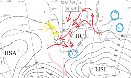
A rare phenomenon occurred this week over the long stretch of the interior plateau east of the escarpment. From the Angolan border in the north up to the Orange River in the south, the central plateau experienced higher barometric pressure in the east compare to the somewhat lower pressure over the western half. This created mild conditions, similar to Oosweer, across the entire central strip. The southern African sub-continent was dominated again by a high pressure cell with its core, at surface level, located over South Africa, and its upper air extension leaning away to Zambia. The slow but steady anti-clockwise rotation of this cell, causes the air to flow from the east over the Omaheke and Otjozondjupa regions, from the north over the northern half of the country, and from the north west over the Kunene and Erongo regions. This rotational movement establishes a band of lower pressure that originates in Angola and migrates south until it is present over the whole coast from north to south. It is not a trough in the true sense as the pressure is still about 1018 mB, and even 1022 mB on Wednesday morning in Walvis Bay, but it does establish a pressure differential. In very simple terms, the barometric pressure over Botswana is higher than at the coast, creating a mild airflow from east to west but not strong enough to cause genuine Oosweer at the coast. The escarpment acts like a natural barrier restricting this east to west airflow, causing it to settle over that strip of the interior plateau west of the mountains separating the coastal plains from the higher ground. And since high pressure cells are by definition descending columns of air, the so-called anabatic effect comes into play.
This is when, in a high pressure cell, air descends and compresses, it gives off energy and the result is a marked rise in the ambient temperature. For instance, the lower lying areas in downtown Windhoek approached 27oC on Tuesday afternoon, repeated on Wednesday but not with such dramatic effect. Keetmanshoop briefly reached almost 30oC earlier in the week. In meteorology, this is know as bergwind conditions, or anabatic compression. At the coast, the result is very visible and we call it Oosweer. Over the interior, it is not nearly as visible and there is hardly any wind at all due to the high pressure presence, but the rapid rise in surface temperature, is the surest sign of descending air. At weather stations it reveals itself when barometric pressure gauges remain stubbornly high in spite of solar heat. The combination then of sun and descending high pressure, makes the surface temperature go unexpectedly higher. Coupled to a dominant airflow from the north, mild conditions were experienced countrywide up to Friday, when the picture changes. While the first half of the week was firmly in the grip of the high pressure cell to the east, Thursday and Friday were dominated by a strong low pressure system south of Cape Town. The Sperrgebiet experienced good spillover with extensive low level cloud formation, and even some light winter rain. The nights remained cold, getting substantially colder towards Friday, as the next South Atlantic high pressure cell neared the continent.
What’s Coming?
Friday sees a rapid drop in temperature, especially in the Hardap and Karas Regions. The South Atlantic high makes landfall during Friday night, driving a weak cold front ahead of it. Saturday and Sunday will both be cool days, and again the rule applies, cold in the south, cool over the central parts and mild in the north. But this cold intrusions is moderated by low pressure control in the upper air which effectively takes the sting out of the winter bite. Very cold nights in the south will be offset by bearable days and as early as Sunday evening, temperatures should improve, but now in reverse order. First in the north, and then progressively warmer in the south. The presence of the high pressure is of brief duration. It is weakened by solar heat as it migrates across the sub-continent and already by Monday, pleasant weather returns. The rest of next week should see a similar pattern as this week, cool to cold nights, pleasant days and warm afternoons.