


Agriculture Ministry warns of possible flooding in the lower Orange River, and eastern Zambezi floodplains
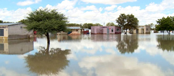
The Ministry of Agriculture, Water and Land Reform (MAWLR)has issued an alert to the public, especially those in the Lower Orange River, and Eastern Zambezi floodplains of possible high river flows and flooding which might cause prolonged inundation in the coming days.
MAWLR Executive Director, Ndiyakupi Nghituwamata in a statement said the ministry has learned that there is high rainfall development in the main headwaters of the Vaal-Orange system in South Africa.
“As a result, major overflows and releases had to be made from Bloemhof, Gariep, and Vanderkloof major dams over the past weekend. The high flows moved down the Lower Orange River and at Blouputs, the water level started rising rapidly since the afternoon of Friday, 17 February 2023 from 0.52m to 3.33 m on 20th February 2023,” Nghituwamata said.
According to her, the major upstream dams remain above 100%. “It is expected that the flows in the Lower Orange River will remain high in the coming weeks with more water on its way, as a result of further overflows and releases from the upstream dams.”
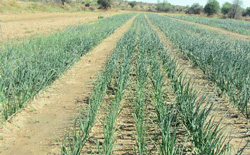
Communities, Water Users, Irrigation areas (Noordoewer, and settlement in Aussenker), Mines, road users, the lowest part of the Orange River Oranjemund area, etc. are advised to be on high alert for possible high river flows and flooding.
Meanwhile, the ministry said the Zambezi River level maintains its steady rise at Katima Mulilo.
“The first flood wave reached the Zambezi River at Katima Mulilo early last week. The river starts overflowing its banks when it reaches the 4-meter mark at Katima Mulilo. The hydrological station recorded 5.29 m on the morning of 20 February 2023. Early higher flood alert and readiness are advised for the eastern Zambezi floodplains as river levels are expected to rise due to good rainfall development in the upstream part of the Zambezi catchment,” she noted.
According to Nghituwamata, the water levels in the channels of the eastern and central zones of the Cuvelai ephemeral river system are leveling off, however, the levels remain high for this time of the year. The observed high levels may exceed the 2011 flood, being the highest recorded flood in recent memory in the Cuvelai Etosha Basin if more rains persist in the Cuvelai catchment.
Namibia flood-prone areas include the Cuvelai-Etosha Basin, Okavango River, and banks, Zambezi River banks and eastern Zambezi floodplains, Lower Kuiseb catchment, Hardap – Downstream of the Fish River- Mariental, the Lower Orange River and the Kunene River. Therefore, communities that live in flood-prone areas are advised to be on alert for possible flooding events and emergencies.
According to the SADC SARCOF seasonal rainfall forecast, this year will be a La Nina year, which means that normal to above-normal rainfall is expected.


