21 February 2014
![]() What happened?
What happened?
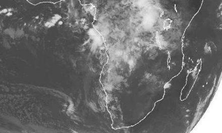
The most prominent feature of this week’s daily synoptic charts is the strong cyclonic low-pressure core that develop in the Mozambican channel. The first gyration became discernible late last week. The depression grew in strength over the weekend and by Monday it was a marked tropical cyclone.
As the week progressed it slowly migrated south, and continued to intensify, so much so that by Wednesday it was given a name. Known as cyclone Guito, its core pressure on the ocean surface has dropped to 989 milliBar, indeed low enough to be classified as a tropical cyclone. Vertical velocity inside a low pressure core can be considerable and Guito is no exception. What it means is that it exerts an influence on weather patterns through all atmospheric layers, from the surface up to 50,000 feet, where it peters out and due to its rotation, spreads like an open umbrella influencing the weather for many thousands of kilometres away from the core. This is also the case with Guito. Despite being some 2000 km away from the Namibia Botswana border, it advected a massive amount of moisture over a very vast area of the southern African subcontinent. But, equally dominant, and persistent, is the ever-present high pressure cell over the south Atlantic ocean.
The approaching high opposed the Indian Ocean low leading to a so-called convergence line, i.e. where the two meet. This line is usually quite prominent and situated most often along a line more or less from Ruacana in the north west to Aroab in the south east, but it does move either west or east, depending on the dynamics between the opposing forces. The convergence line played a big part in this week’s rainfall which, for the greater part, remained west of the convergence line, following the western escarpment. The outcome was light rain from the Kunene region, across Erongo, the western half of Hardap, and the western half of Karas, then curving back over the Orange River valley with isolated showers up to the Kalahari. In the upper air however, were the telltale signs of another high pressure system, this time south east of South Africa. In the 2013 summer, this same high pressure cell exerted much influence in the alto levels, above 35,000 feet, over the western half of southern Africa. During the summer, the regular inflow of moisture from Angola and the DRC, was time and again depleted by the influence of this high pressure cell at the very high level. The result was the drought.
Now it has appeared again, but its core has shifted to a point south of Madagascar with the result that it is now depleting the moisture over the central plateau of southern Africa. The interplay between low and high pressure systems produced a week with much promise but very little actualisation. Rainfall was widespread, even down to the south western part of the Karas region, but it produces only isolated, brief falls, with very few readings above 5mm. PS. The Namibia Meteorological Service has become psychic, managing to publish the rainfall for the 20th, already on the 19th.
What’s coming?
Conditions for the circulation of moisture over the western half of Namibia remain favourable but intensities will be scant. The Inter-Tropical Convergence Zone has moved further north by some 800 km and is now situated over central Angola from west to east. Chances of it approaching Namibia and entering our airspace are slim, but with the strong zonal flow east to west, i.e. from Mozambique to Angola, surface and middle layer airflow will continue to advect some moisture. Rainfall expectations for the whole country remain positive, but restrained. As the high pressure cell slips around the southern Cape, the wind will be southerly, then south easterly backing to east and eventually north to north westerly. This will help improve conditions for local rainfall, but do not expect fireworks. However, widespread rain is expected for most of next week for most of the country excepting the coastal plain.