Understanding Weather – Not Predicting – 27 January 2012
What happened?
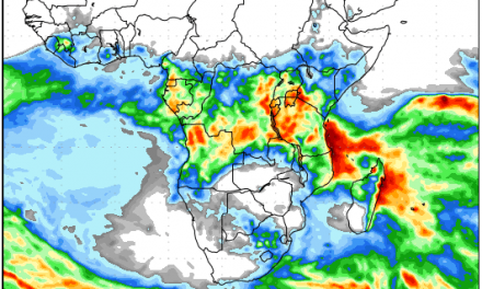
For yet another week the Inter-Tropical Convergence Zone, the so-called ITCZ, remained visible on synoptic charts covering the southern hemisphere. The western end of this inter tropical front showed a weak but persistent vortex just to the west of the Kunene estuary, extending across northern Namibia as it became most actively identifiable as the intense tropical cyclone “Funso” in the Mozambique Channel.
Thence it stretches across the Indian Ocean (spawning another tropical vortex) into northern Australia (2 more equatorial lows) thence to the Pacific, close to New Zealand. There it faded with two north-south troughs the only evidence of its mid-Pacific activity.
Over the central Pacific it disappeared emphasizing the still-evident La Nina providing adequate Trade Wind flows to control the weather across the tropical Pacific. This broad synoptic view was well reflected in the weather patterns presents in our skies.
The stationary nature of the whole ITCZ scenario kept moist air present across north and north-eastern Namibia,
Cyclone Funso, unfortunately another aspect of global warming, has thrived on 29oC and warmer sea surface temperatures present since New Year in the Mozambique Channel. It has been fed from the north by the North East Trade Winds as well as the (very much weaker) input from the south.
The southerly input while keeping the Tropical cyclones active (this is number 2) has also been divided in its ability to feed the markedly present heat-low seen for some weeks now from western Namibia to the south-western Cape. This is another example of the north-south command of La Nina.
Anticyclone cores have, equally consistently, held the 40oS latitude as a home range. Although not back in full strength, their summer influence has become more pronounced but their ability to shove the rainmaking systems across southern Africa is still rather limited.
Within the Temperate vortex zone, embracing Marion Island, two cold fronts have passed by the Cape of Good Hope. The final one south of Cyclone Funso has developed a true Temperate vortex which helps draw the cyclone southward.
So, for the first January since 2007, there has been a lengthy duration across a large part of Namibia in which rain has been scant.
Whats coming?
As Cyclone Funso drifts south, it moves across cooler water and starts dissipating. By next week Tuesday, its remnants disappear as does its grip on local weather. With the southern African synoptic returning to a more normal range, the ITCZ, active over Zambia extends more towards Namibia bringing Congo air across the northern half of the country. The persistent hot low pressure system across eastern Namibia and adjacent Botswana attracts a moister inflow of some depth (about 5000ft).
Although anticyclonic presence stays strong enough to ensure a west-wind push, also towards the heat low, by mid-week the lower level wind-flows above the coast and the adjacent Atlantic show an ability to switch to northwesterly, with the expectation is that moist air will flow across much of the country. Unfortunately, this happens only in the mid-level altitudes, so rainfall, although widespread, will not be intense.