20 December 2013
![]() What happened?
What happened?
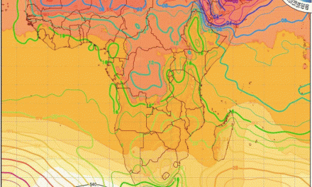
Anticyclonic control of the synoptic patterns has been based on the South Atlantic high pressure core fed from both Tropical and Polar front convergence to the north and the south. This core may vary somewhat in its charted position either east or west but its presence feeds the lower level, mobile, cores as they intensify and drift eastward while the upper core resides high above the Atlantic.
From this synopsis, for a few days a zone of lower pressure activity saw some 3 or 4 shallow vortex cores shape only to wander east or weaken and collapse as a new secondary formed to the west. This complexity was to be found from south of the Cape (35oS) down to the periphery of the major polar front activity at 45oS, covering the entire southern Africa up to Madagascar. There was little chance for moisture inflow.
Meanwhile the low pressure area synonymous with the hot season brought the Congo airmass further south. This airmass and its identifiable core, the Barotse low, ensured consistent, daily, rains from eastern Angola, the Okavango catchment, and east into Zambia.
In general, this as an outline matches the “climatic norm”, the zone of activity being some 5 to 10 degrees of latitude south of this “climatic norm” marks the mix of both past and present where our synoptics are concerned.
During these few days, therefore, rains have kept to their more usual ranges for this time of year, while maintaining their favourable weather pattern presence on our doorstep. Only from the Kavango region eastward does December feature as a core month (the first of the four) of the rainy season.
So for much of the country sunny skies prevailed beneath a shallow southerly flow while this pattern joins the eastward drift into this new week. Such conditions favour the strengthening of the heat inspired low pressure area above southern Namibia, which draws in moisture from the north.
What’s coming?
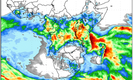
Two authoritative forecasts show widespread rains starting over the weekend and continuing for at least eight days. Interestingly, the Outjo and Otjiwarongo districts are indicated as the area where the heaviest activity will be by next week Tuesday and Wednesday.
For most of the country except the desert zone, there is a reasonable chance of a wet Christmas.
Advection from the periphery of the Congo air assisted by the departure of the southerly flow sees a return of convective activity over the interior.. This intrusion may vary somewhat in the course of the next few days, but for the northern half, the promise of scattered to widespread showers seems justified. With its Congo air influence, the intensity levels look promising with falls of 60mm or more to be expected. On this optimistic outlook more-or-less in place for the rest of the year, this scribe wishes all readers Happy and Holy Christmas into the New Year. I am finally calling it quits, so I wish my readers farewell.