Understanding weather – not predicting 25 October 2013
 What happened?
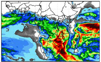
What has become quite a recurrent feature in active weather patterns, is the ability for vortex circulations to develop on the north side of an anticyclonic ridge as this ridge pushes eastward south of the sub-continent. This is historically not an unknown feature, but recently such vortex developments occur quickly and, often, from otherwise unpromising patterns.
This last week gave us yet another example.
One week ago an upper air trough was present to the west of the sub-continent with only a limited advection of moist air from the northwest. Within a few hours, the synoptic patterns showed a tightening of the isobars with the outlines of a closed circulation appearing at the 700hPa level and above. The surface anticyclone’s outward flow was in part drawn toward this deepening upper air vortex. Such an inflow is moist, while the undercutting action serves only to increase the vortex activity and its intensity.
The northwesterly upper flows, away to the east, also reacted to this circulation. A link between both patterns was formed and a zone of some convergence appeared. From this, occasional thunder clouds developed.
Only light showers could be expected as the depth of the moist inflow also had its limits. The vortex now gained impetus from this active inflow and moved quickly east following the ridge as it, too, advanced eastward.
The anticyclonic core from which the ridge had developed now took over. The surface flow (up to 850hPa: our surface level) fed cooler air from about 45oS into and across Namibia, providing relief from the heat of the previous few days but also undercutting the northwesterly airflow so more thundery weather ensued.
By Sunday the whole synoptic pattern lay east of much of Namibia. Because the movement was slower to the north, rather than the south, the moist air mass to the north remained unmoved so providing a core from which future developments could ensue.
The trough line appearance was, again, our synoptic pattern identity.
Rainfall for the week in mm
Outapi 1.9; Tsumeb 1.7; Ondangwa 0.2; Eenhana 1.5; Omaruru0.4; Windhoek HQ 1; Gobabis3.8; Hentiesbaai 2.1; and Karasburg 0.1.
What’s coming?
A new closed vortex appeared above the western Cape coast and moves away by the weekend. A limited northerly extension ensures only limited influence north of the Orange River so keeping our airspace neutral, while the moist presence from the Okavango remains present and active and penetrates somewhat further south as the renewed anticyclonic presence to the far southeast maintains lower level inflows towards this area of lower pressure. The redeveloping surface heat- low pressure area remains in place over central and southern Namibia. Thundery weather lies east of this trough line.
As weather patterns build into the new week the next low pressure pattern shapes by mid-week, yet again.