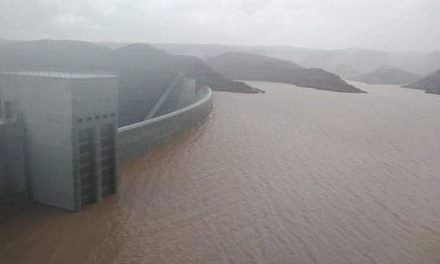
Kuiseb River currently at 1,25 m after peaking at 2,5 m 24 hours ago, its highest since 2013

By Clifton Movirongo.
The heavy rainfall sustained over the course of several days in the Khomas Hochland to the west of Windhoek resulted in the Kuiseb River flooding, after the water level of the river reached nearly 2,5 metres on Monday.
The water level on 25 January at approximately 05h20 was its highest peak in close to a decade.
Martin Handjaba, a Senior Researcher (Atmospheric Sciences) at the Gobabeb Research and Training Institute, said the Kuiseb River is currently reported to be approaching Rooibank, but added that its speed has reduced so much such that it is not expected to go much further unless it gets another boost from upstream.
According to information made available to the Economist, the Kuiseb river first came past the Gobabeb Research and Training Institute, which is about 95 km from Walvis Bay on 11 January and the highest depth for this particular flowing event was 1,2 m for most of the day until it started gradually subsiding. This was followed by another boost on 14 January taking it to a level of 1,3 m before subsiding and again another boost on 16 January taking it to the same level until it completely dried up on 21 January.
“The river came down again on 25 January in the morning measuring a level of 2,5 m, the highest since 2013. As we speak the level is at 1,25 m but rapidly subsiding,” Handjaba said.
He added that although the water levels in both events would easily cause flash floods in many other rivers, the sandy bed of the Kuiseb River drastically reduces the speed of the water.
“However, this is only true for the central Namib which is the last quarter of its journey to the coast. Flash floods are more likely to happen in the rocky highlands upstream. The Kuiseb River is also very wide in the central Namib allowing water to flow without breaking its banks,” he said.
Namwater Chief Water Supply for Business Unit Coastal, Coenie Koegelenberg said, “as a rule of thumb, we are getting worried if it is above 1 metre. Yesterday it rained inland so we are expecting it to rise again. The first wave came through to Dorop without any damage to the water supply infrastructure.”
Koegelenberg further explained that the closest monitoring of the water is at the Gobabeb research facility and “now we wait and see what comes next.”
“As for damage to property, none such was reported by either us or the Topnnaar community living on the banks. There are however some inconveniences and opportunities created by the flowing Kuiseb. The Topnaar community keep livestock which mainly depends on the river for food resources as the dry plains offer none this time of year. This means community members will have to feed their livestock from their stockpiles to discourage them from going into the river which may lead to possible drowning, especially for small stock,” said Handjaba.
Local tourist operators, on the other hand, are getting their hands full with hundreds of visitors coming down from all over Namibia to get a glimpse of the flowing Kuiseb River.
“As for the Gobabeb Institute, access to the dunes for researchers and their respective research sites has been cut off causing varying degrees of disruptions to some projects but on the bright side, it brings much-needed water to life downstream and breathtaking scenery,” Handjaba concluded.


