Understanding Weather – not predicting – 30 August 2013
What happened?
June to August are the tail end of the “rainfall year” calendar.
On top of large temperature fluctuations, this August has provided late winter rain in the Karas Region. This week, while frost occurred in the South two nights in a row, the North went above 30oC during the day.
Such wide divergence is expected in this time just before Spring. Couple that with colder air flows from far south of the continent and it leads to a clash between warm and cold air masses (closely situated) and weather’s response is wind. What has correspondingly occurred, due to the daytime heat, is the early response of a heat-low during the day. This is unusual for our time of year perhaps, but this can account for the development of seemingly convective cloud band identifiable from Angola to our southeast.
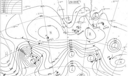
A semblance of a link with an approaching trough to the southwest can be inferred. A key missing link is the absence of a middle cloud at Altocumulus level. The 8000 feet distance between the 700hPa and 500hPa level is minimal by surface level standards but as practical observation and experience of weather station and aviation reveals this is a potent range of atmospheric activity.
So apart from hot and cold hand-in-hand, occasional cloud and continental haze what else was there? The discerned arrival of a major upper air trough with mid-latitude vortex core duly arrived with a promise of some rain materializing across the southwest. Rosh Pinah Exxaro topped the list with 7.5mm, Aus, Klein Vista: 4.2mm, Warmbad: 2.1mm, Karasburg Agriculture 0.5mm, Ariamsvlei:0.3mm and Oranjemund with 0.8mm received the most cohesive rain of this dry winter.
The final input of last week’s anticyclone was to steer some moisture toward the system covering the Karas rebion on Wednesday and Thursday.
What’s coming?
This whole pattern is squeezed eastward during this Friday while the succeeding low-level ridge (identifiable below 700hPa: 10,000 feet) arrives close to Marion Island but is unable to block the eastwards vortex flow. The core of the ridge away to the west is also pushed by an active vortex core which, by Tuesday lies south of the Cape. Its frontal advance is given scant northward thrust, while being pushed by cold air. It is likely that the second complex of cold fronts, currently about 6 days away over the south Atlantic, may lead to another influx of moisture during the first week of September
More wintry cold has arrived this Friday morning with temperature in the south dropping again to close to zero. The cold clears the haze from the skies though so by Sunday, the day will be warmer as a northerly flow returns. The northern half of Namibia remains warm to hot. The cold will linger somewhat longer though over the Kalahari east of Keetmanshoop.