Understanding Weather – not predicting – 16 August 2013
What happened?
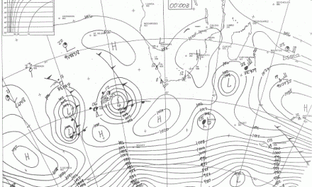
A week ago, there was the prospect of a colder weekend coupled with an active, but mobile, vortex lying just south of the Cape.
This new vortex was not to be driven, deepening in intensity, so enabling deeper airflow to surge northward on its western side meaning a thrust deep inland. Sufficient was this evolving pattern in intensity to disturb the lower and middle air synoptics and to prevail for most of this week.
Intermittent cold air invasions, particularly in the lower (up to some 8000 feet) levels took over.
For much of the country, where winter had barely been felt, the advent winter cold, had truly arrived. Overnight minima hovering around 0oC with frost, were recorded. Daytime maxima struggled to ascend the 20oC mark and there was a breeze (August at work) to accompany this generally cooler presence.
This signals an overall late sequence to the seasons. Rain, such as it were, could only make a very late start and now winter too. Computer models based on past actuals are unreliable to accommodate these deviations and their ability to track unexpected changes is thus limited. So many charts offer “Sea level synopses” across our sub-continent which for the most part lies above the 925hPa level with about one half matching the 850hPa level. The effect of this plateau (and escarpments) upon various air flows, offers various possibilities. Couple this with the shifted synopses responding to the change in climate and the scenario achieves complexities removed from the normal range previously expected for our arid climate.
The exposure to the unusual is prominent. While this set of patterns prevailed, the upper level disturbances helped bring a few showers to our far southwest, again late in the winter season. Observations indicated quite impressive dew and white frost for an area southward from about Grünau.
Veld deterioration is becoming observable.
The north remained warm, though.
What’s coming?
Anticyclonic control persists to the west, with ridges proceeding across the southern continental interior between troughs with limited northward extent and weak upper air support. Cold intrusion seems limited.
Over the northern half, the airflow will keep to its easterly orientation while the central and southern parts should see varying flows from both southeast and east more obvious by next week.
The prospect of showers remains minimal.
Nights keep on the colder side, but daytime warmth is more evident for the northern half. Wind remains at least a daytime factor for much of the country. As long as the dominant airflow remains easterly or tend to back easterly after a cold intrusion, mild oosweer will be experienced at the coast. Overall, the weather is still firmly in the grip of a typical winter pattern