Understanding Weather – not predicting – 31May 2013
What happened?
After a prolonged season of an abnormal weather pattern, over the past few weeks, that stubborn deviation has given way and reverted to a more conventional, expected pattern. During this week, the synoptic charts presented an early winter pattern that is in line with expected conditions.
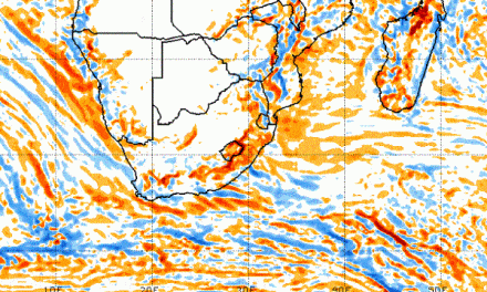
These consisted of cold front extensions coming close to southern Namibia so bringing closer the prospect of winter showers to the south. These have been scarce in recent seasons.
Historically our south could rely on winter rain recurrence across the May to September period with a level of certainty better than our summer-autumn expectation which is dogged by the Arid Zone identity of variability.
Present synoptics present these frontal extensions driven by anticyclonic cells which, and here is the mix, form far to the south of their normal (about 30oS) range. This complexity sees these cells tending to slip around (south of) the vortex, pushing it somewhat north while guiding the vortex and its higher extension southward, mixing with the warmer air on its western side. North of these events that occur in the southern seas, an anticyclonic upper extension is located east of Namibia.
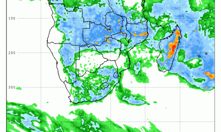
Airflow across Namibia retained a northerly orientation with the potential of tapping the moister fringes still present over northern Angola. This has placed the weather pattern into the position which both resembles the newer and the older so that conditions warm for this time of year prevail (newer) while pressure patterns display typical early winter movement.
Although it is too early for the current pressure patterns to give any indication of developments later in the year, at least for now, they seem to have settled back into a recognisable pattern. The weak cold front of the previous weekend collapsed as it rounded the Cape, leading to a mild, sunny week with little wind, for the entire Namibia. The relatively warm conditions were supported by a constant northerly airflow.
What’s coming?
South Atlantic weather is dominated by an intense trough progressing east and, by weekend, bringing about cloudier skies to the south. At this stage some drizzle is expected below the escarpment across Saturday into Sunday. The trough slips away southeast by Sunday evening. This trough and its almost upper cut-off core are gone by Monday, so restoring the northerly flow across the interior plateau. Such a pattern restricts easterly flows hence no “oosweer” conditions. Clear skies and overnight radiation cooling are to be expected but the chill of winter is limited.
An upper air trough appears by mid-week.
These patterns fit well with both adjacent and distant southern hemisphere patterns, while intermittent ridges do form, extending to Antarctica, strengthening cold front activity and a potential for “cut-off” vortex development: again a mix of foundation weather patterns, while ensuring winter rainfall potential to the area south of the Keetmanshoop Lüderitz line.