


Weekly weather overview and short-term outlook to Wednesday 15 January 2020


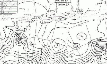
Visual 1: Spaghetti forecast ensemble of sea surface temperatures in the Nino 3.4 region of the Equatorial Pacific Ocean. Forecasts based on observation date 01 December 2019.
Source: European Centre for Medium-Range Weather Forecasts. www.ecmwf.int/en/forecasts/charts/catalogue/seasonal_system5_public_nino_plumes?facets=undefined&time=2019120100,0,2019120100&nino_area=NINO3-4

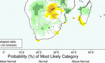
Visual 2: Geopotential height of the 500 millibar surface.
Source: European Centre for Medium-Range Weather Forecasts.
Recent Developments
While it is often difficult to make sense of current weather developments due to the overwhelming noise generated by a myriad of forecasts combined with the irrational expectations of a gullible public, it can safely be stated that the October, November, December rainfall season has not been particularly good in Namibia, certainly not above normal.
Except for the areas north of Etosha, the two December wet spells proved to very erratic, biased to the north-east and eastern areas, and lacking in both intensity and duration. The most obvious symptom, visible to every Namibian and verifiable from independent sources, was the pervasive lack of lightning, indicating suppressed convection hence no or very brief thunder storms.
The question now arises, why is this so and will current conditions continue for the remainder of the season?
Two visuals from the very authoritative European Centre for Medium-Range Forecasts shed some light on what is happening in Namibia.
Visual 1 shows the so-called spaghetti plume for predicted sea surface temperatures in what scientists define as the Nino 3.4 (5N-5S, 170W-120W) region of the Equatorial Pacific. There are four demarcated Nino regions, starting with Nino 1 just off the South American coast, running westward through Nino 2, 3 and 4 up to Indonesia. Due to its immense size and the impossibility to track all conditions across all time, Nino 3.4 is defined as a region in the western Equatorial Pacific covering part of Nino 3 and part of Nino 4. By convention, this area is then used as a proxy for global weather developments that are impacted by either La Nina or El Nino.
The official NOAA position is that the so-called El Nino Southern Oscillation (ENSO) is still neutral but the European centre’s work indicates that sea surface temperatures are expected to remain at or above the +0.5° C threshold, thus indicating a bias to El Nino and not La Nina. In other words, although the current deviation is still within the definition of a neutral ENSO, the tendency is for a warmer rather than a cooler western Equatorial Pacific.
This typically indicates normal to below-normal rainfall in Namibia as a whole but it must be stated that there can be significant departures from the overall scene.
The second visual shows conditions closer to home at an altitude of roughly 18,000 feet above sea level. In this visual one can clearly see the finger-like protrusion from the Atlantic Ocean running across southern Angola, Namibia, Botswana, part of Zimbabwe, part of Mozambique, and up to southern Madagascar. That finger shape is formed by the 5880 metre contour meaning the 500 mB pressure surface is encountered 5.88 kilometres above sea level. This is a relative high reading and as long as the 500 mB surface sits at this elevation, it will not rain in Namibia. This is intermittent high-pressure control at the mid-levels of the atmosphere above Namibia.
Higher 500mB contours indicate ridging while lower values indicate the presence of a trough. As long as there is this high-pressure dominance, convection is absent or suppressed (weak), thunder storms do not develop, and showers are scattered far apart, brief in duration and disappointing in productive rainfall. It can be observed in the mostly flat cloud tops that was a hallmark of the season so far. Only on the odd day or two, did the clouds show good structure with the potential to form tall cumulo-nimbus structures, known by pilots as CBs.
On the Radar
Vapour is visibly intruding Namibian airspace across a wide front and reaching far southward across the central interior but over the weekend rainfall prospects are positive only for the northern half of Namibia. The same pattern of the past two weeks continues with scattered, light showers and very little or zero thunder storms. Temperatures will remain in the mid-thirties for most of the country.
By Monday there is a marked change in the upper atmosphere with the mid-level high pressure control pulling back to the Atlantic. This will allow a deeper penetration of Angolan moisture into the Namibian interior. The rainbearing system develops further to the west, covering most of the interior north of Rehoboth but excluding the northern and central Namib coastal plain and the two southern regions.
Mid-level high pressure control continues over the south-western quadrant with a convergence zone running from Ruacana south-eastward across the interior more or less to Buitepos. North and east of this zone, rainfall prospects are positive while south and west of this zone, zero to scant.
By Wednesday, only the northern half continues to enjoy positive rainfall prospects and by then the system has developed far enough to the west to include the Kaokoveld.
Over the southern Namib and the Karas region it will be blisteringly hot and very dry as this is where the mid-level high pressure control settles.


