


Fortnightly weather overview and short-term outlook to Wednesday 27 November 2019
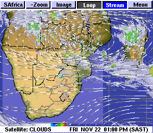
Visual: Anti-cyclonic circulation, clouds and precipitation over southern Africa as on Friday 22 November 2019.
Source: Space Science and Engineering Centre, University of Wisconsin-Madison
http://www.ssec.wisc.edu/data/paw/clouds/eueu_soaf_clds_anim_strm.gif
Recent Developments
The static synoptic pattern of the past two month continued for the fortnight but during the week, the first vestiges of a substantial shift in the overall southern African weather picture have started to emerge.
Until a week ago, the daily synoptic pattern was in essence still in a winter stance. This is easy to recognise: 1.) the anti-cyclonic circulation over the sub-continent was relatively subdued; 2.) the so-called Indian Ocean dipole was neutral; 3.) both the South Atlantic and the southern Indian high pressure cells regularly measured 1024 mB at their cores, sometimes as high as 1032 mB; 4.) the cores of the two highs were often displace to the north, sometimes by as much as 1000 kilometres; and 5.) the mid-level north to south trough over Namibia was either weak or absent and when present, displaced to the east.
The dynamic combination of these five key elements largely determine how our seasons evolve. When the winter pattern remains dominant as it has until a week ago, conditions are not favourable for rainfall in Namibia, except for the Sperrgebiet and the areas in close proximity to the Orange River valley. But these occurrences are spillovers from the winter systems at the Cape, and as such does not form part of Namibia’s summer rainfall season.
The most significant (observable) changes of the past week are the following:
The anti-cyclonic sub-continental circulation is very active. This is shown by this week’s visual. The pivot is currently over the Kariba area between Zimbabwe and Zambia but it only needs to shift about 600 km to the south to the confluence of the Sashi and the Limpopo rivers, at which point it will signal positive rainfall conditions for Namibia.
The two high pressure cells are both relatively weak measuring 1020 mB at their cores and have shrunk considerably in size. The two cores, however, are still displaced to the north by about 600 km. This week the South Atlantic high’s core lay about 1500 west of Lüderitz, too far away to have a meaningful impact in Namibia and sufficiently weak to allow the anti-cyclonic circulation to do its summer magic.
The Indian Ocean dipole is shifting from neutral to positive, i.e. warmer water in the Indian Ocean off the Horn of Africa and the Kenyan coast. Unfortunately, as with many other meteorological pointers in the Indian Ocean, the African research input is rather mediocre so we have to rely on the Met in Mauritius and in Australia. It must be noted that positive or negative for this coupled phenomenon is just a convention. When it is positive, it does not necessarily mean ‘positive for Africa’.
The Indian Ocean Transport is active and linking to the northern rim of the anti-cyclonic circulation. This is perhaps the most positive change although its procession into central Africa is still obstructed in western Tanzania and northern Mozambique but this localised high pressure control has also subsided during the week.
On the Radar
Over the weekend, the approaching South Atlantic high has some influence on the surface over about two-thirds of the country. Temperatures in the interior will be between 34°C and 36°C but in the Kavango, Bwabwata and the Caprivi, afternoon temperatures will again go above 38°C.
As the high migrates around Cape Agulhas, the windflow shifts from south-west to southerly to south-east. This translates into an opportunity for moisture to penetrate Namibian airspace from Angola and Zambia but light rainfall is only expected for the Kavango, Bushmanland and the Zambezi region.
By Monday there is a marked change in conditions as the migrating high moves to the east. It allows much moisture to penetrate the northern half of Namibia with widespread but light rain forecast for the interior east of the escarpment. The clouds may reach south as far as Mariental.
Conditions continue to improve during Tuesday but as the windflow shifts to easterly, the potential rainfall areas shifts to the west. Tuesday may see some rain over the northern half with the bias in the west. There is even an outside chance that substantial clouds may penetrate as far south as the Swartrand, but this will be restricted to areas within 100 km of the escarpment.
By Wednesday, the signature trough from Angola through Namibia into South Africa is in place with light rain expected across the north-western quadrant (below and above the escarpment) with an extension cutting across the interior to the south-east up to the Gemsbok Park.
Note that despite the anticipated 5-day rain window (Monday to Friday), overall conditions are still not positive. Falls may even be heavy (25 mm or more) but will be isolated and of short duration.


