


Weekly weather overview and short-term outlook to Wednesday 03 July 2019
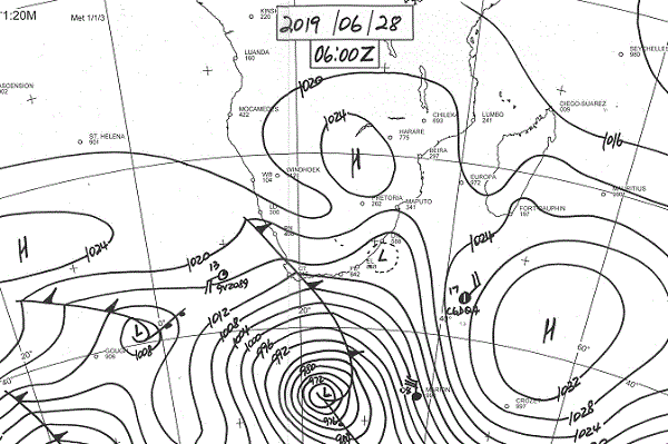
Visual: Synoptic map for southern Africa early Friday morning, 28 June.
Source: South African Weather Service, www.weathersa.co.za/images/data/specialised/ma_sy.gif
Recent Developments
The first strong, proper frontal system made landfall in the Western Cape on Friday, bringing a sudden plunge in temperatures and very windy and rainy conditions. This system has all the potential to push far north across the Orange River and into southern Namibia.
This week started as a continuation of the static conditions of the past three weeks but by Tuesday there appeared noticeable instability in the upper levels of the atmosphere above 18,000 feet. This activity was limited to a relatively shallow layers with a fairly high cloud base.
Nevertheless, roughly between 15,000 and 25,000 feet, a well-demarcated mid-level convergence zone developed with cold, dense air coming in from the south-west in the lower levels, mixing with warmer, lighter air from the tropics. An unseasonally abundant cloud cover resulted that showed some texture on Wednesday.
These opposing systems are readily observable from the ground, they do not necessarily need satellite images to determine their origin, relative strength and direction. What could be seen was that there were actually two layers of cloud. The first was typical winter cloud consisting mostly of cirrus straights that covered the air in long streaks from south-west to north-east. Some distance above these whiffs of cloud, a thicker but patchy intrusion took place, producing the clouds over the central interior that had more texture. However, the development was brief and by Thursday it was back to normal winter conditions.
At this point in the season, surface temperatures present a confusing anomaly. While the southern regions experienced the normal cold winter nights and mild days, the central regions shared the cold nights but had unseasonally warm late afternoons and in the northern regions they are still waiting for the winter. It is an indication of the strength of the continental high (clearly visible in the visual) that produces a stronger-than-usual anti-cyclonic circulation with its pivot more or less over northern Botswana.
In simple terms it means that the advection of warmer air is enhanced, especially in the middle layers, opposing the colder air from the south. The result is that anywhere north of Etosha, from Ruacana in the west to Katima in the east, the daytime temperatures were in the upper twenties with the odd reading of 30°C here and there, particularly in some low-lying areas.
At the coast, very heavy fog was noticed, to such an extent that some weather stations could record the precipitation as more than just 0.0 mm. Also noticeable was the absence of Oosweer mostly due to the persistent westerly airflow and the large pressure and temperature differentials between the ocean and inland.
On the Radar
It seems that the static conditions have turned. There is much expected instability above 15,000 feet covering large areas of the country.
The cold front in the Cape will reach Oranjemund during Sunday with a reasonable expectation that the Sperrgebiet will get a millimetre or two’s winter rain. This system will develop full strength during Sunday night and may even bring light rain to Lüderitz and inland as far as Aus where there is a possibility that it may produce snow.
It will certainly be very prominent in the lower reaches of the Fish River Canyon where it enters the Orange.
The significant disturbance in the south is only the leading rim of the frontal system and by Monday morning, the rest of Namibia will feel the cold. Temperatures will be close to zero as far north as Grootfontein.
The eastern sections along the Botswana border and the South African border south of the Gemsbok Park will feel the impact on Tuesday morning. Even the northern regions will be significantly cooler from Tuesday onwards with nighttime temperatures expected to go as low as 12°C.


