


Overview of weather conditions to Monday 17 June and short-term outlook to Friday 21 June
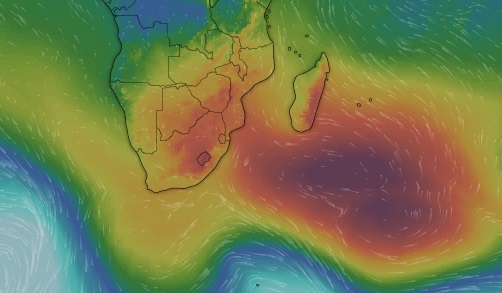
Visual: Computer generated dynamic synoptic map of southern Africa on Monday 17 June
Source: www.windy.com/-Show-add-more-layers/overlays?pressure,-17.225,49.570,3
Recent Development
The visual is an excellent representation showing that winter conditions have finally set in and that the regional stance is one dominated by high pressure.
Last week’s static synoptic maps showed a regular winter stance with the conventional spacing of all local elements. The core of the South Atlantic high pressure cell was situated about 1000 km offshore Port Nolloth indicating that is was slightly displaced to the north. The initial core readings showed a pressure of 1024 mB which is standard for early winter. As the week progressed, the high continued on its migration around the southern Cape, making landfall around Wednesday night and then migrating relatively slowly from west to east across the southern parts of South Africa.
The southern Indian high sat south-east of Madagascar with a much stronger core reading of 1032 mB, reaching back to the African coastline bringing some major winter conditions to the highveld of South Africa and the mountains of Lesotho.
Over the course of the next few days, the South Atlantic high continued on its customary route, morphing into the continental high which is the large reddish and yellow area covering South Africa, Zimbabwe and Botswana. Also visible on the visual is the far reach of the continental high all the way up to the equator in Kenya.
The first proper cold nights in Namibia was not so much a result of the South Atlantic high’s immediate influence but rather the continental high that drove the strong anti-cyclonic circulation over the entire sub-continent. The leading rim of this cell circulates cold polar air from south to north up the Mozambican channel from where it enters the continent and then flows back in a long arch across Zimbabwe and Botswana into Namibia. This is why the cooler conditions over the weekend went together with a soft easterly wind.
This roundabout way for the cold from the south, coupled with the strong anti-cyclonic circulation, leads to cold nights in Namibia over most of the country south of about Grootfontein but it is also what protects the interior against frost. On this long trans-continental trip, although still cold, the air heats up by as much as 10°C before it reaches Namibia.
Later in winter, after the solstice of the coming weekend, these conditions will change as the route the cold air follows will then be much shorter with the consequent danger of below-zero night time temperatures, at least up to about Otjiwarongo.
For the current, the weather is in a fairly conventional early to mid-winter stance and will not change significantly for the foreseeable future.
On the Radar.
The strong anti-cyclonic circulation over the sub-continent continues with its pivot situated over northern Botswana. This can bring some unexpected cold night to the Zambezi and the Kavango Region, and will certainly be felt in the east along the Botswana border.
High pressure ridging in the upper levels is also very pronounced indicating that temperatures north of Etosha will be relatively high every afternoon due to diabatic compression.
Oosweer conditions will be strong over the northern Namib from Hentiesbaai to the Kunene mouth with strong late-afternoon winds on Wednesday and Tuesday.
Frost is not expected yet.


