


Weekly overview and short-term outlook to Wednesday 15 May 2019
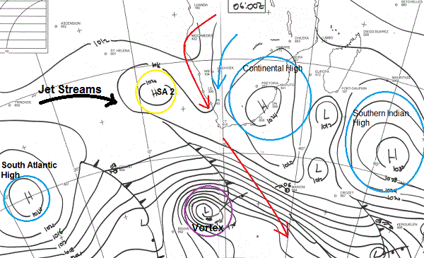
Visual: Synoptic map of southern Africa early Friday 10 May.
Source: South African Weather Service, www.weathersa.co.za/images/data/specialised/ma_sy.gif
Recent Developments
Although the synoptic map is for Friday, it closely mirrors conditions earlier in the week when a prominent mid-level trough demonstrated the power of seemingly separate systems to generate big surprises when these systems link up or combine.
The mid-level trough was still rather undefined over the previous weekend being effectively blocked by the South Atlantic high as it morphed into the Continental high, sitting due south of Cape Town with extensions to both west and east.
At the start of the week, the cold front that shows on the visual just below left of the Southern Indian high, was still approaching the Western Cape, due to make landfall later that evening. Its movement created the conditions over the Cape which amplified the budding trough over Namibia.
The mid-level trough over Namibia, running from Angola to South Africa is one of the signature features of Namibian weather. It is almost always present during summer and it often lingers long into the early part of winter It is the conveyor of moisture from the DRC, Angola and Zambia. It may be a few hundred kilometres further east or west, often shifting position unexpectedly depending on the approximate offshore distance of the South Atlantic high, or ridging from Botswana, depending on the position of the Continental high.
On Tuesday, as the cold front was passing the Cape, it created a marked north to south airflow, helping to pull the southern end of the trough over Namibia southwards to the Orange River.
A trough is defined as an area of lower pressure that extends between two areas of higher pressure, often with a very dynamic (unstable) atmosphere as a result of the opposing rotating directions of the two high pressure systems.
It is easiest to understand the effect of the trough when it is viewed like an enormous river of continental proportions that runs at elevations between 15,000 and 25,000 feet with the two adjacent high pressure cells as the river banks.
This trough advected central African moisture into Namibian airspace for about 24 hours leading to widespread but localised, isolated falls ranging from 0.5mm to 4mm. This is not very significant but for May it is.
It was quickly pushed away in the alto levels by the jet streams, indicated in the visual by the fat black arrow on the left. For the remainder of the week, Namibian skies were clear and relative humidity only around 20% or less.
By Friday, a second similar system has begun to develop with the only exception that the continental high is now in the east, indicating much ridging from Botswana over the weekend, and conditions behind the approaching cold front are fairly calm.
On the radar.
The two red arrows show two different systems, very similar to ten days ago. The top red arrow is the emerging mid-level trough, while the bottom arrow shows the north to south airflow ahead of the approaching cold front.
The combination will lead to windy conditions over the weekend, especially over the northern coastal plain and the adjacent escarpment. In general, Namibia’s northern half will be windiest with the wind getting stronger the closer to the escarpment.
The presence of the Continental high over South Africa indicates ridging over Botswana and into Namibia meaning that the surface airflow across the eastern half will be mostly from the east. Temperatures in the Kalahari along the South African border and in the Karas region up to the escarpment should soar on Sunday.
There is also an outside chance of light Oosweer along the coast but this will be restricted to the northern Namib from Walvis Bay northwards.
For next week, Monday, Tuesday and Wednesday are expected to be quiet, open, sunshine days with minimal influence from Botswana as the continental high departs.
By Wednesday next week, conditions are very similar to this week, with lower pressures over Namibia’s western half and the South Atlantic high straddling the Western and southern Cape. There is however, not a single forecast that shows any form of precipitation over Namibia.
Interestingly, earlier this week, two fairly reliable weather organisations indicated another bout of light, late rain around 15 and 16 May, but changed that view on Friday, not expecting anything to materialise next week.
The passing of the cold front over the weekend is not expected to bring any cold weather to the Karas region.


