


Weekly overview and short-term outlook to Wednesday 08 May 2019

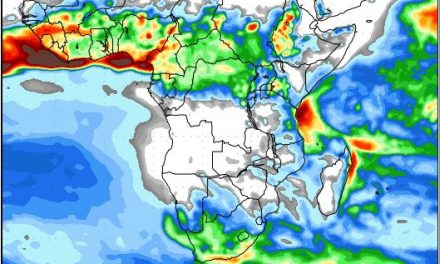
Visual: Colour-enhanced surface pressure map for southern Africa on Friday 03 May.
Source: Meteoblue.com, https://www.meteoblue.com/en/weather/map/pressure/africa
Recent Developments
Namibian weather has settled into a fairly regular inter-seasonal pattern and will probably continue like this for another three to four weeks. The synoptic may at the beginning of the week showed both the South Atlantic high pressure cell and its southern Indian Ocean counterpart in their regular spots either side of the continent, roughly equidistant away and of comparable strengths although the South Atlantic was initially slightly weaker.
Over the southern African sub-continent, the dominant airflow was anti-cyclonic driven in part by the northern rim of the southern Indian high. Between the two offshore highs was the signature mid-level trough, very weak over Namibia but growing in strength deeper into South Africa. The result was some very intermittent cloudiness around 15,000 feet on Monday and Tuesday but this soon dissipated. For the remainder of the week the skies were a clear blue except for the Kavango and Bwabwata which saw some moisture enterrd from Zambia.
The Inter-tropical Convergence Zone has made a dramatic departure from a month ago with its southern boundary now situated far north in Angola, fairly close to the DRC border. This is also the reason why Namibian airspace remained clear despite the presence of the weak trough.
This week’s visual shows barometric pressures on Friday morning. Notice that the South Atlantic high has made landfall in the Western Cape and is just starting to move along to the southern Cape. Ridging from the east has also much subsided but with relative humidity less than 20% over the Namibian interior there is not much source material for cloud formation let alone convection.
The notable feature on the visual is the low pressure system reaching down the northern Namib coastline from Angola (the red area). This is not expected to advect any moisture from the north but the pressure differential will cause much wind from Swakopmund further north. This will blow hardest late afternoons when the interior has heated up considerably after the high pressure induced cool nights. It is a regular occurrence and the coastal residents are fairly used to a south-westerly wind starting around 11:00 in the morning, increasing in strength until about 16:00 after which it slowly dies down with very calm conditions around 22:00.
With the South Atlantic high so prominent, there is little room for Oosweer, even after the high has completed its trans-continental migration. (Oosweer happens when there is ridging (high pressure) over Botswana and a low pressure system offshore the Namib)
The visual shows dead-quiet conditions over the interior with fresh winds over the northern Namib and adjacent areas in Erongo and Kunene.
On the Radar
There is limited high pressure control in the alto levels indicating that the hot afternoons will continue over the weekend and into next week with the northern Namib still the only exception.
The previous high departs but the successive South Atlantic high is already on the radar. By Sunday the departing high will cause a little ridging over Botswana but with the next high approaching, a high pressure system will also be relatively close to the coast.
In between, running across Namibia from north to south will be a band of lower pressure which may lead to generally windy conditions with a mild north to south airflow.
There is no precipitation of any kind in the outlook for the whole country.
The weak north to south airflow eventually morphs into the customary mid-level trough which may bring some patchy clouds. A strong low pressure system approaches the Cape by Sunday evening, amplifying the formation of the trough over Namibia.
It is only by Tuesday that the trough has grown to regular strength (for autumn) and there may be some interesting developments in the Karasburg district along the South African border, and along the Orange River valley.
There is an outside chance that the presence of the trough may bring in some mid-level and alto level clouds over the interior but the odds are small. If this happens, it will be very brief, lasting less than two days. By Wednesday evening the entire Namibia should be back to clear skies.


