


Overview for the Decad and short-term outlook to Friday 26 April 2019
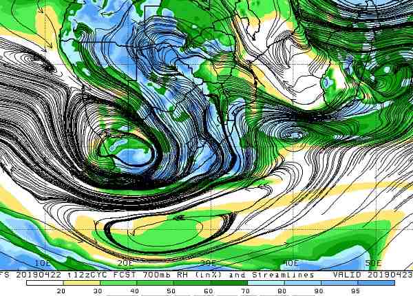
Visual: Relative humidity and airflow (black lines) at 700 mB (10,000 feet) at noon on Tuesday 23 April.
Source: Climate Prediction Centre of the National Oceanic and Atmospheric Administration of the US Government
www.cpc.ncep.noaa.gov/products/international/cpci/data/12/gfs_700mb_rh_safrica.html
Recent Developments
The period leading up to full moon on Saturday saw a marked increase in humidity, a lowering of the cloud base and a persistent northerly airflow.
At the beginning of last week, the remnant of the previous week’s mid-level trough sat over the Kavango, extending into central Botswana. It slipped out of Namibian airspace by Tuesday (except the Zambezi) but was rapidly replaced by another mid-level trough, active between 15,000 and 30,000 feet, in the more familiar position from southern Angola into the Namibian interior, continuing into South Africa.
This development took about three days to come full potential and late on Thursday, the first significant clouds started appearing over the whole Namibian interior above the escarpment. However, the widespread distribution of moisture was not sufficient to trigger the clouds. It needed another push, or rather a pull, and that came from the south.
In the upper levels of the atmosphere, a strong low pressure disturbance developed over the Western Cape reaching north up to and beyond the Orange River. The combined effect of the northerly airflow (from Angola) at mid-levels and the strong pull from the low pressure system (south) in the upper levels, created conditions that lead to widespread light rain from a very low cloud base. The end result was a wide spectrum of intensities ranging from light rain (2.5mm) to heavy (but isolated) thunder showers on Thursday, Good Friday and Saturday.
On Sunday, the clouds cleared from the west but still leaving enough room for the trough to work its magic on Sunday and Monday from the Kavango River through the north-eastern quadrant all along the eastern border up to the Orange River in the south.
By Monday evening the trough was still extant, having shifted in the north to a position more or less across Bwabwata and in the south to the western part of Botswana, just outside Namibian territory.
The visual shows conditions at midday on Tuesday. The blue band clearly indicates the trough’s route while the adjacent green zones indicate a relatively high humidity but probably not sufficient to lead to any precipitation.
Note also the circle described by the black lines just south of the Orange River, and the second elliptical circle a few hundred kilometres south of Cape Agulhas. This circle is the core of the South Atlantic high, and as often happens during the seasonal transition, it sits for a few days due south of the continent with bulges to both the west and the east. Since the South Atlantic high is such a strong animal, its influence on the atmosphere stretches many thousands of feet aloft, so it acts as a barrier to the trough from the north. This effect was also seen over the weekend with copious, enduring rain over large parts of the southern half of South Africa.
Also noticeable was the continuous heavy rain in central Angola indicating that in another four weeks or so, both the Kavango and the Zambezi rivers should be very high. There is also a chance that the Kunene will benefit from the rain in central Angola but incident data is unfortunately very limited.
The feature to watch is the tropical depression just north of Madagascar. In the visual its outer rim is just visible as the blue section in the upper righthand corner. That system is expected to develop into a proper cyclone and hit northern Mozambique and southern Tanzania by Thursday, with Malawi in line a day later.
On the Radar
The South Atlantic high, currently enveloping the southern limits of the continent, takes its time before moving east. It indicates that it will continue, at least for a few days, to block the continental trough which now runs from Western Zambia through Botswana into South Africa.
While there is still a small chance of rain in the Kavango on Tuesday, the high pressure ridging in from the east (Limpopo and Botswana) suppresses convection consequently reducing the chance for rain. Interestingly, even the Caprivi and Bwabwata are expected to be clear for the next four days.
On the western perimeter of the high in the east, a northerly airflow is maintained, unfortunately restricted to the mid-levels not exceeding 20,000 feet aloft.
The result will be considerable cloud build-up, increasing daily for the duration of this week, and slowly developing backwards (from east to west), i.e from the Kavango into Ohangwena and Oshikoto. From there is will developed further west into Oshana, Omusati and Kunene and even further south but it will only be over the northern half of the country.
It is only by the weekend that a marked shift in conditions is expected, and then with a strong bias in the west. The impact of the tropical storm bearing down on Mozambique remains to be seen once it moves over land.


