


Weekly overview and short-term outlook to Wednesday 20 March 2019
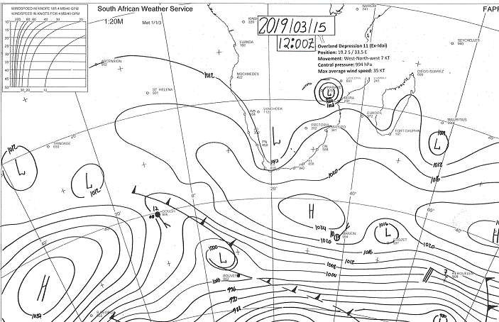
Visual: Synoptic map for southern Africa at Friday 15 March
Source: South African Weather Service www.weathersa.co.za/observations/synoptic-charts
Recent Developments
The visual for this week show only two significant items in what is otherwise a fairly regular synoptic pattern.
The first is the remnant of Tropical Cyclone Idai which migrated down the Mozambican Channel from Monday to Wednesday when it made landfall in central Mozambique. From there it degenerated quickly into a tropical depression with heavy rain north of Beira but restricted to a small area. The impact further inland was minimal.
The second important feature which is far more important to Namibia, is the position of the 1024mB cores of the three high pressure cells spread from west to east of the continent. Note that all three cores are more or less at the 40°S latitude.
The continental high south of the continent is for us the most significant because its core has shifted by a good 1000 km, very similar to its movement three weeks ago. The South Atlantic high’s normal summer trajectory usually takes it around Cape Agulhas so it is not always a reliable indicator of what the position of the next approaching South Atlantic high will be but when all three cores are at a similar latitude, it provides a fairly reliable indicator that the high pressure belt’s main activity has shifted south.
This is corroborated by the other high pressure cells in the rest of the hemisphere and can readily be seen on any of the NOAA charts that map the entire southern half of the globe. This is potentially a good sign for Namibia albeit very late in the season.
This small beacon of hope is unfortunately neutralised by the 30-day Southern Oscillation Index of the Australian Bureau of Meteorology. It has almost gone off the charts over the past month reading minus 15 this week. This is a very negative signal for southern Africa as there is a strong observed correlation between the Southern Oscillation Index and summer rainfall in southern Africa. The only consolation is that the western fringe of the sub-continent sometimes receives more rain when the index is strongly negative, but this is not based on empirical evidence. It has been observed only intermittently and not document in any scientific study.
For the first part of this week, coastal conditions were marked by a fresh to strong southwesterly wind which tended to pick up in intensity as the day progressed and then subsided around midnight This is the result of the significant pressure differential between central Botswana, where it is unseasonally hot, and the Namibian coastline, where it is unseasonally cold with foggy conditions that push deep inland, almost like a winter pattern.
A weak mid-level trough ran through Namibia from north to south for the duration of the week but it was only by Wednesday, when the South Atlantic high has migrated to a position south of the continent, that good cloud formation started to appear. This was followed by widespread showers on Thursday and positive conditions carrying on into Friday. But the rainfall continued to be very isolated and brief.
The typical measurements were between 5 and 15 mm. Severe drought conditions that are now exacerbated by the ongoing poor season are firmly established over the entire country.
On the Radar
Over the weekend, the tropical depression over Mozambique fizzles out and moves deeper inland. Heavy rain is expected to continue over central Mozambique moving to eastern Zimbabwe.
In Namibia the signature north south mid-level trough remains in place, extending west to the edge of the escarpment, same as it has done on Thursday and Friday this week.
Overall conditions are rather static with a hot central Botswana and higher pressure just off the Namibian coastline. This indicates that the south-westerly fresh to strong winds at the coast will continue.
With the trough remaining over Namibia, cloud formation will again be good over the interior reaching west to the escarpment, but alto conditions are negative so convection is suppressed. As with this season so far, it can literally rain anywhere over the north, the central high ground and into the south-eastern corner (not further south than Gochas), but it will at most be jaloersreen. A good, well-developed system is not in the outlook.
The outlook for next week is very similar: hot interior, strong south-westerly winds at the coast, much cloudiness east of the escarpment, and intermittent, isolated, brief showers. Even the northern regions, from Kunene in the west to Zambezi in the east, are not expected to see much rain, if any at all.


