


Weekly weather overview and short-term outlook to Wednesday 20 February 2019

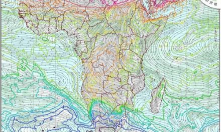
Visual: Computer rendered colour map of sea level pressure for southern Africa on Thursday 14 February.
Source: GFS / NCEP / US National Weather Service as published by windy.com, www.windy.com/-Show-add-more-layers/overlays?pressure
Recent Developments
This week’s visual has been chosen from a range of similar charts to show the extent and impact of the South Atlantic High Pressure cell, the single most important dominant force in Namibia’s weather.
For the duration of the week, the same daily pattern was replicated from early morning to early evening. At sunrise, the skies were mainly clear with only some alto level cirrus-nimbus clouds, again showing more of a late winter / early summer pattern than the expected mid-summer stance.
As every day progressed, humidity at surface level decreased, indicating rising air, while the temperature quickly reached 30°C across the entire country above the escarpment. At this stage, usually by about noon, some cloud build-up has started slowly drifting to the south-west from its source in the north and north-east.
By late afternoon, some good cloud cover was observed but the really intense clouds were only present over the Ohangwena, Okavango West, Otjozondjupa and Omaheke regions. Cloud development also followed a regular daily pattern, becoming more visible on satellite images as the day progressed.
The moisture would slowly condensate in a broad band from the Okavango, southwestward, first moving into Otjozondjupa and then into Khomas until it reached the escarpment on the other side of the Hochland. From there it deflected due south, running for about 400 km before it was repelled by the outer rim of the South Atlantic high as it moved in over the southern Namib. On its final leg, the clouds moved back inland crossing central Hardap and into the Karasburg district.
Most noticeable was the promising look of rain every afternoon which eventually fizzled out during the first half of the night, with very little, if any, convection. This is very easy to observe: No convection, no lightning.
The visual provides an easy-to-read format showing that the South Atlantic high carried out its customary mid-summer trajectory, slowly creeping around the continent from west to east and then moving up the Mozambican Channel and ridging back over South Africa’s Limpopo Province, southern Mozambique and Zimbabwe’s lowveld.
The visual also clearly shows the area of lower pressure over the west-central parts of the subcontinent. This makes it easier to understand the rainfall pattern. Where the map shows yellow or green, the chances for rain are less, or even completely absent. Only where it is blue is there a reasonable chance for precipitation. Note also, that even Angola, Zambia and northern Mozambique are subject to limited high pressure control – not conducive for rain in Namibia as it blocks the route the moisture has to travel to reach us.
By Friday, the contiguous high has already split into two, setting up conditions for a mid-level trough next week that is expected to run from Angola through Botswana into South Africa.
On the Radar
Conditions over the weekend remain fairly static for the Namibian interior. The only exception is the Kavango, Bwabwata and Caprivi where a well-demarcated convergence zone is expected to develop.
There is a slight intrusion into the eastern parts close to the Botswana border, spreading deeper into the interior on Sunday but again with only limited rain prospects, and only from Windhoek further north.
On Monday sufficient moisture is still extant over the northern half but it will be a repeat of this week. Much promise with little rain although some heavy, very isolated falls may be experienced. No rain is expected for the southern half.
By Tuesday, the mid-level trough has developed to such an extent that there should be a broad intrusion of moisture from Angola running across Namibia from north to south. This leads to improved conditions for rainfall in the southern half by Wednesday. This activity will be limited to the interior above the escarpment.


