


Overview for the week and 5-day outlook to Wednesday 21 November 2018
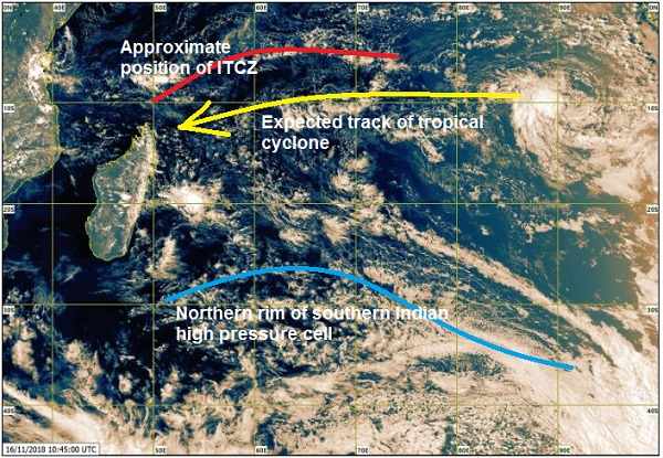
Visual: Satellite image of central Indian Ocean on Friday mid-morning 16 November
Source: Mauritius Meteorological Service, http://metservice.intnet.mu/satellite-imagery.php
What Happened
This excellent image of Indian Ocean conditions show a number of elements that point to expectations for the Namibian summer rainfall season.
In the top righthand corner is the first sign of a tropical depression. This has the potential to develop into a tropical cyclone which generally follows the east to west trajectory as indicated by the yellow line. Cyclones are low pressure systems by definition, i.e. rising air that rotates clockwise hence the name cyclone. These systems drive ocean evaporation and as such, they are immensely important to pick up moisture from the sea and convey it into all levels of the atmosphere.
This is already the second budding cyclone in less than a month and relatively early in the austral summer. If proper cyclones continue to develop at this rate, the vapour over the Indian Ocean will be much elevated later in the season.
The blue line shows the northern rim of the southern Indian high pressure cell as it slowly migrates from west to east. The direction of airflow, however, is from east to west. Together with the vapour generating activity of the cyclones, this airflow is the key conveyor of moisture from the Indian Ocean to the African continent. It is what is called the Indian Ocean transport and if it does not function well, central Africa, and then later southern Africa, suffers depleted moisture levels.
The Inter-tropical Convergence Zone indicated in red is usually an indication of the dividing line between the tropical low pressure area and the high pressure zone to the south. This line only indicates the southern boundary and is inferred by observing cloud formation and rainfall patterns. As the summer progresses, the ITCZ becomes more defined, stretching across Africa from Mozambique to Angola. The latitude of its southern boundary is a very good indicator how close to Namibia a significant source of moisture is. Currently the ITCZ over Angola is well-defined and sits more or loss across the middle of the country. It will slowly move south and by Christmas should be located on the Namibian Angolan border.
In East Africa, the ITCZ is currently absent or undefined mostly due to a fragmented atmosphere stemming from high pressure control in the troposphere that flows up (south to north) the Mozambican Channel. At this point it is a negative signal. If the atmosphere over East Africa does not consolidate by the austral solstice, the Indian Ocean transport is restricted and much less moisture reaches central Africa.
Locally, the week was marked by extremely hot conditions carrying on for more than a week. This is a typical heatwave and it shows up on 500mB charts as a cell in the stratosphere that is “thicker” than the surrounding areas. It is an indication of how high the atmosphere reaches aloft. This week it went as high as 60,000 feet with the cloud base only starting at 20,000 feet. This very thick airmass above Namibia, Botswana, northern South Africa and southern Angola, produces temperatures near 40°C as it settles and sinks.
What’s Coming
Heatwave conditions continue on Saturday over the central plateau and the central coastal plain. The Karas region and the northern regions fall just outside the heatwave zone but temperatures are now so elevated, it will require at least a week to normalise. This implies that the whole country will be very hot during the weekend.
There is limited localised convection expected over the Khomas Hochland and the adjacent coastal plain to Walvis Bay. This should produce ample cloud but without rain. It does help to reduce the daytime temperatures.
By Sunday the immediate elements responsible for the heatwave have begun to normalise and a weak trough becomes visible over Namibia following its customary route from around Ruacana, skew across the country to the Karasburg district. This will produce significant cloud and there is potential for localised falls, even heavy thunderstorms, but in the typical jaloersreen fashion it may rain 40 mm in one area and zero just five kilometres away.
Hot days continue next week on Monday, Tuesday and Wednesday but not as hot as this week.
By Tuesday, the impact from the approaching South Atlantic high pressure cell is felt over the Karas region and Wednesday morning may even be surprisingly cool in the Karas, Hardap, Omaheke and Khomas regions
Rain prospects are bleak next week with only a small chance of early season rain over Bwabwata and Zambezi.


