


Overview for the week and 5-day outlook to Thursday 06 September 2018

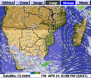
Visual: Eumetsat infrared image of southern Africa during Friday night, 31 August / 01 September
Source: oiswww.eumetsat.org/IPPS/html/MSG/IMAGERY/IR108/BW/SOUTHERNAFRICA/;
Border and town overlay from www.weatherphotos.co.za/
What Happened
This week is marked by a weather picture showing considerable contrasts, not only in the spatial arrangement of elements, but also in the temporal development from early in the week to its end.
At the beginning of the week, the South Atlantic high pressure cell had a very perculiar shape and position. It stretched more or less from the South American coastline to the other side of Africa, just south of Madagascar. It did not display its usual potato shape which is typical for the winter summer transition, but was more like a fat sausage bridging the entire South Altantic between the two continents.
This position prevented a proper cold intrusion as the high functions like a buffer between the southern seas and the African continent, forcing cold fronts to pass south of Cape Agulhas. But the core that covered most of the area south of the Orange River still had a pressure of 1024 mB, indicating very cold, dense air. On the high’s southern rim, the airflow is from west to east, but this happens far out to sea, south of South Africa. On its northern rim, the airflow is the opposite, from east to west, and this band of active air usually runs through Zimbabwe and Botswana, penetrating Namibia from the east, bringing very cold conditions to the Karasburg district and further north along the Botswana border. This was also witnessed by the strong easterly airflow on Monday, backing to north-east on Tuesday, and then due north for the rest of the week.
In addition to the cold wind from the east, other local effects were the windy, dusty conditions in the southern Namib, and the almost Oosweer in the central Namib.
Once the wind direction has switched from easterly to northerly, it opened the door for warmer, moist air from the north. This effectively split the elongated high into two. The South Altantic core retracted to the west, while the continental portion went on to morph into the southern Indian high pressure cell.
By Friday, a more usual late-winter synoptic pattern emerged with the South Atlantic high’s core about 1000 km west of Oranjemund, the southern Indian’s core only a few hundred kilometres south of Madagascar, and a weak mid-level trough running from Angola through Namibia and Botswana into South Africa. Only near the Indian Ocean coastline some vestige of the departing high was still present.
The visual shows a fragmented convergence zone running from an offshore position north-west of Walvis Bay through the central Namib, covering the Hardap and Karas regions and from there into southern Botswana and the South African interior. The brighter the white colour, the higher and colder the clouds are. Light grey areas offshore the west coast indicate the outlying rim of the approaching South Atlantic high, and the absence of a well-developed frontal system.
The satellite image is a two-dimensional view (from aloft) of a very active, mobile three-dimensional system, and must be appreciated as such. Hence it is important to distinguish between sea-level systems and those higher up.
What’s Coming
As the weekend begins, a very regular synoptic pattern is in place. The South Atlantic high with a core reading of 1024 mB is about 800 km west of Oranjemund. The southern Indian high has a considerably stronger core at 1032 mB but it is located far south of Madagascar at 40°S latitude. The 1024 mB isobar, however, covers the southern part of Madagascar.
Namibia is located more or less in the middle between the two highs, indicating that late winter / early summer conditions will continue for the next few days.
The northerly airflow over central Namibia has brought some cloudiness to the interior but these are at the middle layers around 15,000 feet. On the surface, the weather is split into a northern and a southern half. In the south, cloud formation is enhanced while the north will only see scattered mid-level clouds.
The airflow will remain northerly until Tuesday night when the South Atlantic high will start impacting weather in the Karas region.
At this point, the jury is still out, but there is a reasonable expectation for a cold intrusion starting Wednesday in the south, and then spreading east and north during Thursday and Friday.
The variance between forecasts is huge, two indicating temperatures near or at zero for the southern and eastern regions, while two others expecting the nighttime temperature not to go below 6°C. The difficulty in accurate forecasting is typical for the seasonal transition, and it is typical for Namibia.
In all likelihood, the expected cold intrusion in the south should reach as far north as Grootfontein while the far northern regions and the north-western section above the escarpment should see hot to even very hot days with a build-up of clouds in the Kavango, Bwabwata and Zambezi.
Editor’s Note:
Elsewhere in this edition under the Environment tab is an article on the seasonal forecast issued last week by the Southern African Regional Climate Outlook Forum. It mentions a so-called “false start” to the rain season. Namibians need to pay attention to this.


