


Overview for the week and 5-day outlook to Wednesday 29 August 2018
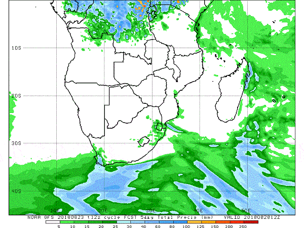
Visual: Accumulated precipitation from 24 to 28 August
Source: Climate Prediction Centre in the US govt National Oceanic and Atmospheric Administration (NOAA), www.cpc.ncep.noaa.gov/products/international/cpci/data/12/gfs_precip_day5_safrica.html
What Happened
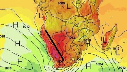
The synoptic progression for the week followed a regular late winter pattern. Some anomalies were present in the sense that both the South Atlantic and the southern Indian high pressure cells showed abnormally strong core readings, but at the same time, both slipped southward as the week progressed, diminishing their direct impact on the continent.
Local weather was characterised by the large differences in nighttime temperatures between the southern, central and northern regions. Windy conditions reigned for the entire week across the whole country. Noticeable was the difference in wind direction. In the south, the wind blew mostly from west to east and in the north from east to west. This is a clear signal of the transition from winter to summer.
Conditions in Namibia’s southern half were still directly impacted by the South Atlantic high while further north, the strength of the anti-cyclonic circulation is growing by the day bringing in tropical air from Zambia and Angola. In Windhoek, more or less at the centre of the zone where these opposing systems meet, the to and fro is seen in the cool nights with a southerly to south-easterly wind direction, versus the warm afternoons, which is a combination of warmer air flowing in from the north-east, and later in the afternoon aided by diabatic compression as the airmass sinks due to upper air high pressure control.
This see-saw weather phase will continue until the South Atlantic high consistently keeps to its customary position at about 33°S, or even further south, and until its core pressure subsides to 1024 mB. In the meantime, abrupt alternating intrusions of cold from the south and warmth from the north, will also continue.
Two more features, very much at play during the week, are the inferred cloud base and relative humidity. When the cloud base is high, i.e. above 16,000 feet, humidity plunges to less than 10% and local barometric pressure reads between 1024 and 1020 mB. As the stance reverses during the day, the pressure drops to below 1020 mB and humidity quickly shoots up to between 15 and 20%. At the same time, the cloud base sinks to around 12,000 feet. This is the most reliable indication of the daily interplay between opposing southern and northern systems.
By the end of the week, the South Atlantic high’s core has shifted far south, straddling the 40°S latitude but with enormous strength, reading about 1036 mB. The southern Indian high is also displaced to the south, but with a somewhat weaker core at 1028 mB. Only a weak remnant of the continental high was still in situ over the South African interior.
What’s Coming
The visual shows the outlook for precipitation for the five days starting this Friday, 24 August. As expected, there is no rainfall on the charts for Namibia but the biggest contribution to the accumulated rainfall for the Western Cape will come from a strong frontal system that will make landfall during Saturday and last through Sunday into Monday.
The South African Weather Service has issued warnings for the Western Cape for heavy rainfall and even “disruptive’ snow on the mountains forming the south-western curve of the escarpment.
In Namibia, the expectation is for very windy conditions in the south during Saturday, followed by a cold night, and a cool Sunday. In the north, conditions will remain warm to hot, with the first vestiges of spring present in Bwabwata and the Zambezi.
From Sunday to Monday, the migrating high will ridge in from South Africa via Botswana with considerably colder conditions in the Karasburg district, the areas along the Gemsbok Park border and in the Kalahari along the Botswana border.
This will result in a substantial pressure differential between Namibia’s east and its west with very windy conditions along the escarpment later on Monday and into Tuesday.
Conditions will normalise during Tuesday night and by Wednesday it should be a warm to hot early summer day with light wind from the north.


