


Overview for the week and 5-day outlook to Wednesday 25 July 2018
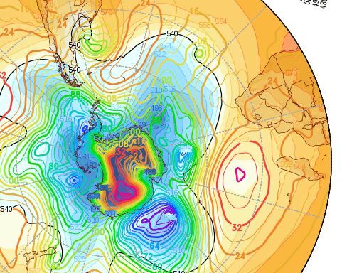
Visual: Clip from the sea level pressure chart for the southern hemisphere on Friday 20 July
Source: GrADS/COLA, George Mason University, http://www.wxmaps.org/fcst.php
What Happened
The outstanding feature of this week is the sedentary position of the southern Indian high pressure cell. The visual shows its core located about 500 kilometres south of Madagascar, extending laterally for perhaps 1000 km. The core’s reading on Friday was a strong 1036 mB with a small epicentre reaching 1040 mB. This is indeed a strong cell and its continental impact can be seen in the 1024 mB backward extension that covered two thirds of southern Africa.
The reason why it is so static is to be found in the position of southern Africa’s main weather driver, the South Atlantic high pressure cell. For most of this week, it was weak over the central ocean, with only a relatively small core immediately east of Patagonia in Argentina. From there the journey to Africa takes a good six to eight days. Since the usual eastward push from the South Atlantic high was absent, the southern Indian high had no reason to budge and remained in its current position for the better part of five days.
Although the atmosphere over South Africa and Zimbabwe was intensely cold, that effect did not reach Namibia. With high pressure control over the eastern half of southern Africa, a strong anti-cyclonic air circulation was present over the continent but the distance the cold air has to travel to reach the western side of the subcontinent, is a roughly 3000 kilometres.
In the meantime, the sunshine hours per day keep increasing steadily so the energy reaching the ground every day also increases. Longer distance to travel and more sunshine heat the cold air and by the time it reaches the Botswana Namibia border, it is about 10°C warmer than when it left its source on the eastern side of the subcontinent.
Coupled with the large distance offshore of the South Atlantic high, it resulted in a pronounced north-easterly airflow over Namibia, and although the nights were still cold, the warmer air brought pleasant days. In the south it was somewhat colder, but not backbreakingly cold, and in the north it was warm to hot.
With the anti-cyclonic circulation came moisture and this manifested in a very broad convergence zone that on Thursday covered the entire north from the Kunene in the west to Bwabwata in the east. Substantial cloud formation developed over the north, moving into the Otjozondjupa and Omaheke regions late on Thursday, but the surface was still subject to high pressure control which forced the cloudy layer higher, above 15,000 feet.
The remnant of this system was still visible over the interior on Friday, but it was obvious that the clouds were very high, too high for any precipitation.
What’s Coming
By Saturday the South Atlantic high has moved closer to the continent but it is still far out to sea, slightly more than 2000 km. With the southern Indian remaining static, its backward protrusion (continental high) also remains in situ. But as with this week, the cold effect is confined to South Africa and Zimbabwe.
Ahead of the South Atlantic high is the usual frontal system with a relatively strong vortex (low pressure core) just north of the 540 dam line. This line indicates the position of the front. Ahead of the line, temperatures stay above zero while behind it, freezing conditions occur.
But since it is a vortex, it implies that it has a very strong cyclonic circulation and it lifts the cold air behind the front aloft. This mechanism depletes the leading rim of the high with the result that the cold does not intrude very far north on the surface.
This is what is expected by current forecasts. Whereas the cold front is fairly strong, it is weakened by the vortex in the front ahead of it. It amplifies the anti-cyclonic circulation over the subcontinent, much like a cut-off low would do in summer.
For Namibia it spells a pleasant weekend, perhaps slightly warmer than this week, and a continuation of mild to warm conditions over the interior for Monday and Tuesday.
It is only by next Wednesday that the South Atlantic high reaches the continent. Its impact will however be restricted to the rectangle formed by Lüderitz, Aus, Rosh Pinah and Oranjemund, in other words the former Sperrgebiet, now the Tsau //Khaeb National Park.
It is not expected to cause frost, even in the Karas and Hardap regions but it will lead to cold nights over the interior above the escarpment next week Wednesday, Thursday and Friday.


