Understanding Weather – not predicting – 20 December 2012
What happened?
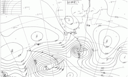
”Weather” is renowned for its ability to achieve the unusual and do so with scant advice to the onlooker. A week ago a quite familiar synopsis was present with a moist band to the north and an active, cut-off vortex above our southern skies. These patterns usually depart quickly, clearing away in a matter of hours.
But there was much surprise to follow.
The northern pattern drifted westward, limiting precipitation quite considerably across the northeast: few showers were noted and the activity to the west was also limited. Diversity of airflow patterns across the area and with altitude emerged as the pattern unfolded. The slack wind-flows one finds in proximity to the zone of convergence which characterises the equatorial rainfall belt do bring about a level of stagnation. Both the Cuvelai and Kavango catchments only had downpours typical for this time of year.
To the south, though, the cut-off aspect provided for a shallow (scant vertical extent) anticyclonic core to thrust south of the upper vortex so to make it even more “cut off” before continuing its eastward move. Such a delay enables activity (cold air undercutting for instance) to be enhanced: considerable downpours resulted. This is quite normal but in this case the cut-off feature is unusually late in its time range and whether or not it can tap a moist tropical air to power its activities may not readily be identified.
Such patterns are not long-lived. In this case barely 36 hours saw the full development and consequent departure, but in so doing the pattern built a storm area which brought 50mm measures within a single rainfall day. For the Karasburg area and the month of December these (scarce at any time of year) are not previously on record. A further bonus lies in the spread of the rain across some hours rather than the (to be expected) minutes, indicative of such downpours. More distant activity recorded similar unusual falls to the east with both Aroab and Gochas’ detail topping 20mm.
Already this new rainfall year has seen some unusually heavy falls spread across hours rather than minutes providing penetrating values rather than run-off water.
For the in-between remainder, December provided the heat and the promise, coupled with increasing cloud, to see out the week.
What’s coming?
The pre-Christmas outlooks maintain the spread of moist air above much of the country, departing briefly but returning quickly in response to the mobile synoptics close to and around the Cape.
A new upper air cut-off vortex appears above the east Atlantic during the weekend, collapsing before mid-week as it nears the Cape, enabling the new surface ridge to push and redevelop, with a resurgence of lower level maritime air toward the shower belt building east of the interior low pressure area.
Middle level tropical air turbulence and convergence persist above both Angola and Zambia maintaining moist air presence adjacent to our air space: an amenable situation for the time of year!
From this scribe, Happy & Holy wishes for the season until 2013