Understanding Weather – not predicting – 09 November 2012
What happened?
That weather is notorious for its complexity and diversity, and in our case for its erratic unpredictability.
Despite global warming, the dominant features of the sub-Tropical High Pressure Belt remain evident.
The expectation of anticyclonic cores to be found at the various levels, from surface deep into the Troposphere is fulfilled, so why the increased complexity?
Anticyclonic cores at surface levels with limited upward extension are shallow by definition but they are also mobile. They do not have a vast upper extension to hinder their thrust behind the vortex’ cold front.
A ridge usually forms around 30oS, pushes eastward, breaking from the parent, and advances along a higher latitude. It then combinse with the upper core away to the east while a new ridge starts again in the South Atlantic. This process is continuous and it happens with regular monotony. In winter the ridges are more pronounced at the surface level while the major activity shifts to the upper levels during summertime.
Lately, the global warming influence sees these surface cores consistently along 40oS or more indicating a displacement of between 1100 km and 1600 km. (every degree of latitude equals 111 km)
For seven of the past nine summers, this has created space for the Inter-Tropical Convergence Zone, where moist air rules, to wander further south, bringing above normal precipitation to Namibia. We experience it as floods.
The high-pressure ridges extend towards the polar region. This advects unusually warm air south so creating intense, deep vortex cores (below 950hPa) while polar air adds to the cold front’s identity. This allows secondary vortex cores to evolve in the turbulent cold air, weakening the initial system and-disturbing the expected synoptics accordingly.
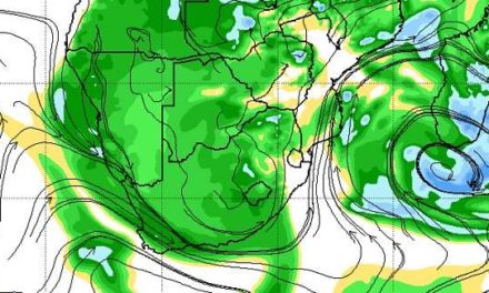
This past week gave evidence of this complexity as the departing anticyclone consistently fed a shallow layer of moisture in over the north western and central parts.
The shower intensity relies on strength, or lack of it, of the upper-air core. Too strong and the cloud development is restricted, while weakness allows for good, local development.
Isolated showers there were, but of both limited duration and intensity. Few falls approaching 10mm were indicated. Maximum temperatures readily got up to the high thirties.
What’s coming?
The surface anticyclone moves away by Sunday. A steep upper trough approaches but collapses during Sunday: the complexity lies in there being no cohesion with a matching surface pattern, thus restricting convergence and upward development across all but the northern areas. An anticyclonic upper air core fluctuates during the week, so restricting moist inflows.
The indicated rainfall area remains restricted to the north east with limited intrusion on Tuesday and Wednesday over the north west.
Over the central high plateau, afternoon cloud will form almost daily, but not deep enough to lead to widespread rainfall. Daytime temperatures across the whole country, excepting the coastal belt, will continue to be in the upper thirties.