Understanding Weather – not predicting – 31 August2012
What happened?
Anticyclonic control is the accepted norm across the 15 to 35 degree latitudes, South and North, within the range of the sub-Tropical High Pressure Belt defining the Arid climates, from Sub-Humid to Hyper-arid. This last week gave an interesting adaptation to the measures of control.
The now quite regular diversion of low pressure systems: vortex, cold and warm fronts and upper air troughs seems related to a persistent upper air anticyclone linked to the surface-cored Mauritius High. This has not always been well-marked on the numerous weather charts available, but the feel cannot be denied. Just to make life more interesting, weather patterns to our south and west have provided another range of controls. 3 charts are available at least 2 times a day, so providing grist for this mill. The Sea-level/1000hPa, 850hPa and 700hPa are the ones in question; being from surface through specifically 5000 feet (our level).and 10000 feet.
The recurrent ability for divergence, has seen a marked surface trough barely visible at 5000 feet and a dominant west to northwest flow at 10000 feet. We have also seen examples of the reverse: on the surface we find colder-cored anticyclone beneath a disturbance from 5000ft and aloft. Yet another complexity is the ready ability for a similar situation to develop a separate cut-off low , again diverse through these lower levels, yet active in the middle layers. Yet another active factor has been the ready development of cold, unstable air vortices. These denote another form of secondary low pressure development which depletes the cold push behind the prime cold front (more normally weakend by the process of occlusion), frequently distorting the given track of the vortex as it also weakens. This is not unknown historically but the frequent recurrence expands the range of recent knowledge.
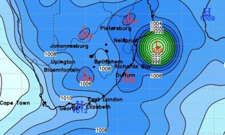
This last week added to the score. First instance saw an active system collapse virtually overnight as it moved south-eastward and weakened, the isobaric pattern flattening while the remains merged into the active synoptics between 45 to 60oS latitudes. Our weather then saw a few showers over the extreme southwest and a limited colder inflow across the south.
Warming was quick, while on a limited 1000 foot level a cut-off vortex formed, drawing in air from above the eastern Atlantic, not a regular moist source, but seeing slight falls (the average for August) occur across a quite wide band of the central to south-eastern interior.
What’s coming?
A similar pattern crosses the far south-west (with showers) only to slip away during Friday. There is colder advection from some 40oS brought into southern and central Namibia but relaxing its push as the wind flow backs from southeast to northeast by Sunday. There after a return to a generally northerly flow ensures warmer day time temperatures. The ability for some easterly flow convective cloud to recur above our northeast persists.
While opinions are still out regarding the mid-Pacific developments, the current patterns looming for our north do match (for once) what we have been used to across previous years. Although this time around, the quite marked divide between north and south cannot be ignored.