


The Week’s Weather up to Friday 19 May Five-day outlook to Wednesday 24 May
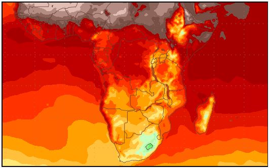
Mean surface temperature from Friday 19 May to Saturday 27 May 2017
Source: wxmaps.org, GrADS/COLA
This week the weather followed a regular intra-seasonal pattern with a marked shift to an early winter stance. The only exception is the continuing easterly to north-easterly wind flow on the surface, leading to pleasantly warm afternoons despite the early evening chill when the sun goes below the horison.
When the larger synoptic pattern shifts from a summer to a winter stance, local Namibian weather displays the typical see-saw pattern where the days are summer days but the nights are almost winter nights.
For the entire duration of the week, the bigger part of the southern African subcontinent was under high pressure control. The leading rim made landfall early in the week, leading to frosty conditions in the Western Cape and southern Cape. The drop in temperature arrived in Namibia a day later, but remained restricted to the Karas Region and only in the east.
The see-saw weather derives from high pressure control in a relatively thin atmosphere. Keetmanshoop provides a good example. With high pressure control from the surface to well above 18,000 feet, it means the upper atmosphere above the subcontinent is intensely cold. As the sun crosses Africa from east to west, it heats up the surface layers but the upper air remains cold and dense. As the surface layer warms it tends to rise but is pressed down from above. The result is a combination of surface heat and diabatic compression, leading to afternoons that approach 30°C. Late afternoon, when the sun is low, the energy in the system subsides, the cold air comes down, and the nights become very cold. These conditions were displayed every day this week being more prominent over the eastern half of Namibia than over the escarpment and the coastal plain. The chilly nights reached as far north as Grootfontein.
Over the western half, a different set of dynamics is at work. With a dominant north-easterly wind flow, the wind blows from the interior over the escarpment onto the coastal plain. The difference in elevation between the interior and the coastal plain forces the air down, it compresses and the result is Oosweer, which can be very mild, as it was over the southern Namib, to windy and hot as experienced over the northern Namib. When conditions over the interior normalise after sunset, the easterly flow stops, and the Oosweer comes to an end, which is usually between 22:00 and midnight.
The Atlantic Ocean then becomes the main influence, the wind direction reverts to south-westerly or south, and the temperature drops quickly. Over any 24-hour period it gives us the typical see-saw hot cold ossicilation.
A feature of the last two weeks is the regular spacing between the high pressure cells of the southern hemisphere with well-defined, prominent low pressure areas in between. Just south of the low pressure area a so-called col forms. This is where the trailing edge of one high pressure cell is closest to the leading edge of the next. These cols function like huge funnels with a prominent north to south airflow ahead of the col and an equally strong south to north airflow in its wake. This movement also helps to accentuate the see-saw pattern.
What’s Coming
The subcontinent remains under high pressure control during the weekend. The continental high pressure cell seems to be well entrenched meaning that over Namibia the dominant airflow on the surface will remain north-east to south-west.
As can be seen from the temperature map, for the next week mild Oosweer over the southern Namib and stronger Oosweer over the northern Namib is expected. The Oosweer north of the Kuiseb will be at its fiercest on Monday afternoon.
The high pressure control reaches all the way to the Congo and Tanzania, obstructing advection of moisture from the Indian Ocean hence zero rain over southern Africa.
A so-called cut-off low west of Cape Town helps to increase the difference in barometric pressure over the ocean compared to the sub-continent’s interior. This enhances the see-saw pattern meaning the days in Namibia will be warm, the nights cold, and the coast will be subject for the entire forecast period to Oosweer ranging from mild to strong.


