


The Week’s Weather up to Thursday 13 April. Five-day outlook to Tuesday 18 April
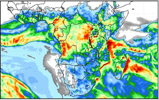
Precipitation forecast from Thursday 13 April to Friday 21 April
Source: wxmaps.org, GrADS/COLA
A prominent mid-level trough swept across Namibia from west to east from Saturday to Thursday.
At the beginning of the week, the trough maintained its position over the western half, only shifting slowly to the east but by Wednesday it has gathered momentum, moving rapidly to the north-east.
The slant at which the trough ran, first from north to south, then from north-west to south-east made it miss the southern Namib so despite good rains over very large areas of the north-western, northern and eastern sections of Namibia, the western parts of Hardap and Karas remained dry.
The trough followed a prominent convergence line showing just what potential power convergence zones may contain, provided the surface layer and upper air meet at just the right elevation with just the right pressure and temperature. Obviously, these three elements were in harmony over the western, northern, central and eastern sections.
Flash floods in Kunene region from the Ugab river north to the Hoaruseb occurred early in the week. This is typical of the Namibian late summer season when higher pressure conditions tend to control the eastern half of the sub-continents and lower pressures are present over Namibia’s western half including the coastal plain.
Widespread rain was also reported in Erongo, Kunene, Owamboland, Okavango, Otjozondjupa, Khomas, Omaheke, Hardap and Karas with some exceptional falls above 60 and even 80 mm.
The synoptic pattern has now moved into a more regular early winter pattern. The Inter-tropical Convergence Zone, however, is still well defined, its southern boundary running from the northern end of the Mozambican Channel across southern Africa into Angola where it is about 400 km north of the Namibia Angola border. The implication is that the Indian Ocean transport is still strong and active, which gives us a glimmer of hope for a continuation of the late rain season. All it needs is a mid-level trough, like this week, and the moisture is advected into Namibian airspace. The bias will however remain over the western half of the country.
By the end of the week, the synoptic map showed a very conventional stance. The southern Indian high pressure cell lay some distance south-south-east of Madagascar with the South Atlantic high about 2000 km offshore Cape Town. In between existed an area of lower pressure with a very strong north to south airflow, amplifying the trough over Namibia.
In Namibia, general airflow on the surface continued the zonal pattern flowing from the Indian Ocean across Mozambique and Zambia into the Namibian interior bringin in moisture in the lower levels, i.e. below the trough which lay at about 18,000 feet. This was one of the contributing factors for the wet week, moisture at both surface and mid-level.
What’s Coming
It is a valid question whether we are at the end of the rain season and if there will be another round of good penetrating rains. The synoptic stance certainly indicates that the sub-continent’s weather pattern has shifted to an early winter stance.
On the other hand, just north of the 18° latitude, conditions are still controlled by a summer pattern, and that is just on our northern doorstep. This implies that a single, low pressure push from north to south, even if only lasting three or four days, has all the potential to bring in moisture again.
And as long as the airflow on the surface remains zonal (east to west), there is still a chance that some Indian Ocean moisture may reach us after travelling the long distance from the Mozambican Channel.
Not to clutch at straws, it must be pointed out that the South Atlantic high will continue to dominate the local weather, so while clouds may form deep into the interior, rainfall will be limited by adverse surface conditions.
Rainfall is indicated for the north-eastern quadrant over the weekend, and for the coastal plain as from Monday. This may even penetrate the southern Namib bringing some light rain to the decimated Sperrgebiet.
Oosweer is again on the map for Sunday, Monday and Tuesday from around Sandwich Harbour northwards. It will shift to the north, becoming more intense the further north one goes.
A cold front crossing the Cape on Thursday and Friday ahead of a constricted South Atlantic high of moderate strength, reaches all the way to the polar circle, so colder nights are in store for the Karas and Hardap regions.


