Understanding Weather – not predicting – 02 August2012
What happened?
The formulation of the polar front into a vortex with warm and cold air boundaries taking on a frontal character identified the synoptic patterns for the week.
Two cold fronts crossed the Cape in rapid succession bringing cold to the south but early this week, the eastern flow returned and so did warmer days. By Tuesday the afternoon was warm again, with only a small nightly reminder that it is still only the end of July. The surprise was the cloud cover that greeted us on Thursday. This is the bottom end of a huge system over Angola, drawn in by a surface trough that covered most of the country by Thursday. This trough (low pressure area) was leaning back in the upper air with the result that it neutralised much of the impact of the cold high pressure system over the Atlantic.
This activity is the hallmark of a highly complex weather pattern which defies long range forecasts.
The cause for this departure from the understood norm is that with anticyclonic cores that much further south, the input of warm sub-tropical air to intensify vortex development is increased while compensatory drive of advected .polar air to accelerate undercutting the warmer air increase commensurately.
It also sees the colder-cored surface anticyclonic ridges thrust round the intense vortex cores, cutting them off from any link with parent vortex systems further south while feeding cold, moist air into this independent core.
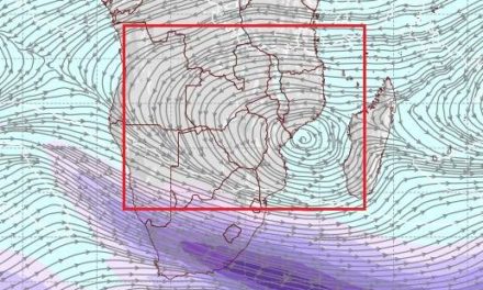
Until mid week, Namibia was just an interested spectator. By Wednesday, an upper air disturbance intensified to a discernible vortex throughout the middle and upper troposphere. A rapidly developing northwesterly air-stream began tapping the air from the 15 to 20oS latitudes. Not a promising moisture source in its initial stage but as the flow comes south it cools to dew point, condensation forms clouds, the cloud mass thickens, precipitation probability evolves.
This pattern was a distant probability a week ago, its development from an otherwise zonal flow is intruiging: there are influences at work not readily observable from the limited station network available across the South Atlantic.
By Thursday, this pattern bore south, west of the coast, with its cloud band mainly above our western parts advancing southeastward. The northern parts remained warm to hot.
What’s coming?
Friday sees this vortex weakens to be absorbed by a major trough moving in from mid-Atlantic reaching the Cape by Saturday, moving on by Sunday. At our levels though, this departure is only apparent by Sunday, colder inflow is only to be felt over southern and central Namibia by Monday morning. The system departs eastward to bring southeasterly flows by Tuesday. Warming becomes evident by Wednesday.
The cold arrives with wind-flow: the discomfort index may be all too apparent. Limited northward push sees little change for the north.
The trough rapidly transforms into an intense cut-off vortex just southeast of the continent (again!), so an easterly flow will be limited.