The Week’s Weather up to Friday 17 February Five-day outlook to Wednesday 22 February

Precipitation forecast from Friday 17 February to Saturday 25 February 2017.
Source: wxmaps.org, GrADS/COLA
Meteorologists are not known for their humour, their subject matter is far too serious but the South African Weather Bureau drew chuckles from old weather dogs when, on Monday, they described the precursor of Dineo as a “Tropical Disturbance.”
It appears, one of the young understudies has never been explained to that TD stand for Tropical Depression.
Nevertheless, all the eyes were on the tropical depression in the Mozambican Channel at the beginning of the week. This system developed, almost overnight into a Tropical Storm, then a Severe Tropical Storm, and finally during Wednesday night into a brief Tropical Cyclone. However, when it moved over land, it quickly lost power, degenerating to an overland depression by Thursday.
By Friday, there is very little left of the former cyclone, with surface conditions having returned to normal. Only in the upper levels above 18,000 feet, a remnant of Dineo was still lingering, crossing Botswana, on its way to the Okavango Delta.
Dineo resulted from the difference in atmospheric temperature at surface level and the minus 56 degrees Celsius at 45,000 feet. Cyclones always need water of at least 29°C, a fairly thick atmoshphere, and a driver, in this case the southern Indian high pressure cell.
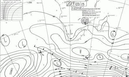
The synoptic anomaly for the week was the strength of the southern Indian high (1032mB) as opposed to the relatively weak South Atlantic high (1018mB). This means that the southern Indian high, some 1000 km south of Madagascar, provided the required cranking on its northern rim. Its anti-cyclonic rotation was all the rising warm air above the Mozambican Channel needed to start its own circulation, but in the opposite direction. From this a depression developed rapidly, morphing into a tropical storm and eventually into a short-lived cyclone.
The same high that kickstarted the vortex, also led to its demise. As the cyclone hit land, wreaking havoc over southern Mozambique, the southern Indian high became stronger, siphoning away to the south-east much of the initial vortex strength resulting in a mcuh weaker low pressure system over southern Zimbabwe.
Although some forecasters gave Dineo an outside chance of reaching Namibia, this will probably not be visible on the surface level. The biggest activity will continue to take place at the 500 mB level with a weak extension to the 300 mB level at around 31,000 feet.
For the duration of this week, moisture continued to penetrate Namibian airspace from Zambia but neutralised to some extendt by the higher surface pressures over the central Namib and the Karas Region.
What’s Coming
Although there is again some atmospheric fragmentation off the Tanzanian and Kenyan coastline, the Inter-Tropical Convergence Zone remains well-defined with a strong zonal flow from the Indian Ocean into central Africa. However, the presence of the low pressure system over central Botswana, the upper air remnant of Dineo, displaces the ITCZ by a few hundred kilometres to the north.
Vapour load is still high thanks to the successive Indian Ocean low pressure systems, Carlos and Dineo, with rainfall indicated for most of Namibia over the weekend. The bias is along the Botswana border from Unie End further north to Bushmenland, i.e. the eastern section of Otjozondjupa and the southern Section of Kavango East.
Sunday in particular, should see the highest spillover of the former Dineo system with heavy falls indicated for Omaheke, Khomas and Otjozondjupa. This system has the potential to take rain deep into the Kunene Region but not onto the coastal plain.
By Monday, the forecasts revert to a more typical pattern with high pressure control on the surface over the western half, and low pressure intrusion from Angola and Zambia over the eastern half.
Overall rainfall conditions remain positive with a weak South Atlantic high, the core of which is displaced towards the south. This leaves much space for the northern (tropical) system to move far south and west.


