


The Week’s Weather 27 January 2017
The week began with a typical mid-summer stance on the synopitc map. Both the South Atlantic high pressure cell and the southern Indian high were in their customary positions, the former offshore the west coast and the latter south-east of Madagascar.
Most of the subcontinent experienced low pressure conditions over the interior. The only exception was the mild high pressure intrusion over Namibia from the Atlantic leading to clear and hot conditions in the Hardap and Karas regions.
The feauture that demanded attention was the moderately strong trough from western Zambia, across Botswana into the South African interior. A strong north to south airflow was present in the Mozambican Channel, pulling the moisture from central Africa in its wake thus reducing the level of available moisture over the western section of the sub-continent.
The South Atlantic high pressure cell has remained offshore for the better part of four months. Typically during summer, this high will slip around Cape Agulhas and move northward up the Mozambican Channel following a fairly regular 4 to 5 day pattern. In the interlude between the departure of the previous high and the arrival of the next, a 2 to 3 day window is created with strong airflow from the north, across Namibia into the South African interior. As the next high arrives, the entire system, while still actively flowing from north to south, is shifted laterally across southern Africa, sweeping the sub-continent from west to east while advecting moisture from north to south. This is the summer rainfall mechanism for the whole of southern Africa except the coastal plain of the east coast and the southern Cape.
This week, a strong anti-cyclonic circulation was present over the sub-continent with its core more or less at the confluence of the Sashi and Limpopo rivers. It functions like a massive aerial wheel, driving the airflow from Mozambique across Zambia into Angola. From there, moisture is advected into Namibian airspace from the north-east and the north but it is opposed by the South Atlantic high from the south-west resulting in a convergence zone that runs from north-west to south-east.
Towards the end of the week, a strong low pressure system developed south of Madagascar with low pressure conditions over the adjacent eastern and southern parts of South Africa. Some spectacular rainfall occurred in the Western Cape on Thursday with the system shifting to the southern Cape by Friday.
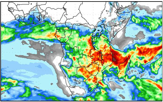
On the Radar
As the South Atlantic high moves overland, it clears away the moisture over the Namibian interior. While rainfall conditions are still positive over the north-eastern quadrant, the high’s influence grows during the weekend, reducing the amount of moisture present in the interior.
However, the advecting mechanism from Zambia remains strong, with rainfall positive conditions for the Zambezi and the Kavango regions.
By Monday and Tuesday, most of Namibia will be clear, with very little cloud development. It is only by next Wednesday that the Zambian system pushes across Bwabwata into northern Botswana and the Kavango again.
The South Atlantic high will continue to dominate conditions over the Namib, the Hardap region and the Karas region but its impact is restricted to the surface. As from Wednesday, rainfall positive conditions return for most of the country except the southern Namib. Strong, but scattered falls are indicated for the northern half, with weaker, isolated falls for the southern half.


