


The Week’s Weather
A strong divergence between surface conditions and upper level movement, continued into this week.
As the week progressed, the impact of the South Atlantic high pressure cell on the surface caused clear skies for most of southern Africa south of the 20° latitude. This is more or less the line running from west to east through Etosha, northern Botswana, southern Zimbabwe and Beira in central Mozambique. The only exception was a weak mid-level trough at the interface between ground and upper levels at the so-called 500 mB surface, around 18,000 feet ASL.
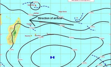
The synoptic may at Friday morning, 20 January showed a conventional mid-summer stance with the southern Indian high pressure cell some 2000 km south-east of Madagascar, the South Atlantic high about 1000 km offshore on the Saldanha Bay latitude and the cores of both reading 1024mB.
As is usual for mid-summer, an extensive area of low pressure reigned over the sub-continent, defined on either side by the outer rims of the South Atlantic and southern Indian highs.
Towards the end of the week, a proper low pressure system developed over the eastern half of the sub-continent leading to a strong north to south airflow over eastern South Africa. This system effectively drained moisture away South Africa, Botswana and Namibia, amplifying the dispelling effect of the higher pressure conditions on ground level.
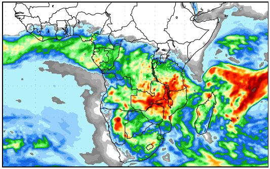
Further north, the southern bounday of the Inter-Tropical Convergence Zone is close to the Namibia Angola border in the west and cuts through Zimbabwe and Mozambique in the east. Over the Mozambican Channel and northern Madagascar, it is well-defined and readily visible. Airflow in the ITCZ is zonal from east to west, indicating that the moisture transport from the Indian Ocean into central and southern Africa is active.
From the interaction between these southern and northern systems, a very large, extensive zone forms, much like a convergence zone but on a continental scale, not restricted to the familiar convergence line between a high and a low pressure system. In fact, this area is so huge, it runs across the entire subcontinent from Angola in the west to Madagascar in the east. It is the area defined by the southern boundary of the Inter-Tropical Convergence Zone.
The effect is a weather picture split into a northern and southern section, meeting in the convergence zone, and further split into a lower and an upper half of the atmosphere. This is indeed a very intricate picture giving some indication of the complexity of southern Africa’s weather during summer. It is also the reason why summer forecasts are so unreliable further than 24 hours ahead. These interfaces between north and south, and upper and lower, are also not static. They are highly mobile and typically shifts by hundreds of kilometres or thousands of feet during a 24-hour cycle.
What’s Coming
Much instability is present in the mid and upper levels above 18,000 feet. The core of the South Atlantic high collapses during the weekend, making room for an intrusion from the tropics, pushed along by the unstable condition in the mid-levels.
Rainfall prospects over most of Namibia excepting the Caprivi and Babwatwa are bleak over the weekend despite a very visible intrusion of low-level cloud from the north-east. It is only by Sunday afternoon that a low pressure system develops from Angola and moves south into Namibia.
The immediate absence of a strong South Atlantic high allows this system to move from north to south into Namibian territory, covering the whole interior above the escarpment.
The system remains in place during Monday, Tuesday and Wednesday with both strong advection and convection. During this time, positive rainfall conditions are in place for the entire country except the coastal plain, but falls will either be low in intensity, or scattered.
By the middle of next week, the South Atlantic high is back, splitting Namibia into a western and an eastern half. The western half will remain dry while the eastern half will continue to enjoy enhanced rainfall prospects.


