


The Week’s Weather
The divergence between surface and mid-level conditions east of the convergence zone is the most noticeable feature of this week’s weather development.
A weak cyclonic surface circulation was present over Botswana between Ganzi and Mohembo on the southern boundary of Babwatwa National Park. This rotation resulted from the opposing wind flows. One stream of air came form the south, following more or less the Namibia Botswana border while the other came from Zambia in the north, crossing Babwatwa into Botswana. Where the two met, the difference in densities caused a rotation, much like a whirlwind, but only on a massive scale. This rotating column of surface air, during its strongest phase, reached all the way from Chobe in the east of Botswana, to around Berg Aukas in Namibia. The ceiling of this activity lay at around 12,000 feet, significantly below the so-called 500 mB surface at 18,000 feet.
In the atmospheric levels above 12,000 feet, the picture was almost the exact opposite. At the 500 mB surface, the circulation was anti-cyclonic which is a standard summer feature of southern Africa. In other words, anomalous conditions were present on the surface while the middle and upper levels displayed a conventional summer pattern with the reigning airflow from the north-east, relative to Namibia.
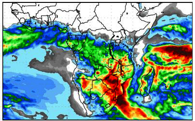
The anomalous cyclonic surface circulation became more important as the week progressed. First, it gradually shifted locus from northern Botswana to north-eastern Namibia. By the end of the week, the core straddled the Namibia Botswana border in the Otjozondjupa region. What happened is that it created a cushion in the lower levels. The airflow from Zambia, where it encountered this column, although circulating in the opposite direction, became unstable, leading to enhanced convection. As the surface column drifted west, so did the unstable column above it, producing a continuous convective zone that covered northern Botswana and the eastern sections of both the Otjozondjupa and Kavango West regions. The end result was high volumes of rainfall, first over northern Botswana and the Caprive, then from Wednesday onward, over Bushmanland. By Friday, it was raining in a very wide band from the Kavango River up to Windhoek. This entire system resulted from the dynamic interplay between surface and mid-level conditions.
But the rainfall occurred only east of the convergence line. While the very active and unstable system was developing over the north-eastern quadrant, the South Atlantic high pressure cell controlled conditions in the south-western quadrant. From last week to this week, the high’s core has shifted southward by about 600 km, now lying offshore Oranjemund. It is of moderate strength, reading 1020 mB, but its outer rim controlled the weather over Namibia’s western half, dispelling the influx of moisture from the north.
Thus, a very clear convergence line ran from the Kunene River, along the western escarpment into the Karas Region. As a consequence, the coastal plain and the whole Namib desert from north to south remained clear, with some excruciatingly hot days over the southern Namib.
Where the high met the airflow from the north-east, a wide convergence zone formed, amplified by the atmospheric dynamics over the north-eastern quadrant. This produced a well-demarcated mid-level trough at the 500 mB surface which acted as a transport channel for moisture from Zambia and southern Angola. The results was wide-spread rain over very large areas inland from the escarpment.
What’s Coming
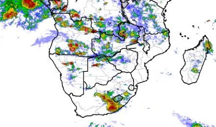
Rainfall remains on the weather radar for the duration of the weekend and into next week. As the South Atlantic high migrates to the east and its leading edge passes Cape Agulhas, a strong south to north airflow moves up the Mozambican Channel and from there across southern Africa. The Inter-Tropical Convergency Zone is well-established and continues to transport moisture from the Indian Ocean in a channel running north of Madagascar, entering the continent over northern Mozambique and from there moving into Zambia, Angola and Namibia.
Conditions are rainfall positive, with much instability over the central plateau from the Karasburg district in the south all the way north to the Namibia Angola border. Enhanced activity and instability in the mid-levels continue to advect moisture from Angola into Namibia. Rainfall is indicated over the northern half of the country for Saturday, Sunday, Monday and Tuesday. By Wednesday next week, the system will have moved into the Karasburg district with a limited chance for rain in the eastern sections of both the Karas and Hardap regions. The coastal plain remains hot and clear.


