Understanding Weather – not predicting – 06 July 2012
What happened?
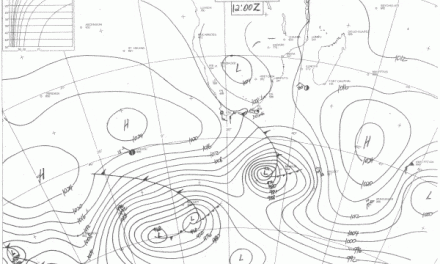
The progression of winter was delayed yet again by another secondary vortex development. Behind the well-marked Atlantic trough, the system weakened, splitting the cold front into two sections by Wednesday. The active sector, closest to the vortex moving well south of the Cape, held track with its cloud band moving at some speed and keeping south of the sub-continent. This is by no means unusual. This season it has happened more than once in the past few weeks. The northern sector of the cold front’s upper trough faded. The remains separated from the vortex circulation pattern and within less than a day became a thing of the past. The result was pleasant days for almost the entire week.
There were two dynamics at work. The first is geographic indicating the role of the landmass in collapsing the frontal system while the second pertains to the turbulent air behind the cold front which tend to create secondary vortices. Both aspects contribute to neutralise the winter effect of the cold front.
As weather events unfolded, it only demonstrated the inability of forecasts to anticipate local conditions. With such rapid arrival and departure of entire systems, a dependable view covers at most six hours. Weather patterns are known but their capabilities and their ability to change their predicted paths is a consistent aspect.
The most dominant feature of southern African climate is the shift in the latitude of the sub-tropical high pressure belt. High pressure cores follow each other with regular monotony as they circle the southern hemisphere. They are the driving engines transporting cold air from the south pole northwards, and reversing this flow once they have past, bringing warm tropical air southward. This is the source of the so-called trade winds.
But over the last decade, the track of the high pressure belt has shifted about 15 degrees further south. And this shift seems to have become permanent. What happens now is that much colder air is conveyed to the north resulting in short but intensely cold spells which we often experience in winter.
While their surface tracks keep to the 40oS line, their upper-air cones, the core of the sub-tropical high pressure belt, persist with their expected 25oS track or so. This pattern is interpreted as the evidence of effects induced by the change of climate.
Across these past few years, ranging to and fro from El Nino to La Nina as recorded in the equatorial Pacific, this pattern is taken as proof of the resultant departure from the accustomed normal range.
What’s coming?
Friday sees the arrival of a steep trough, its precursor cloud band building from Wednesday; it develops further and rainy conditions develop in the south. The whole pattern moves quite quickly and is driven well inland so that by Monday warmer temperatures return. There are 3 cold mornings ahead – Saturday, Sunday and Monday. The arrival of the cold air in the northern half of the country is delayed by a day (Sunday). Widespread frost should be expected. By Tuesday, warmer daytimes return, but this is winter come to call: cold nights persist for the week.
As the cold front passes the Cape, it swing up the east coast, curls back overland and the signature early morning cold wind from the east returns. This happens by Tuesday morning. This easterly airflow naturally leads to “Oosweer” at the coast. Coastal conditions from Tuesday through Friday are expected to be warm.