


Weather 22 April 2016

What Happened
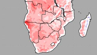
Low pressure control was evident over the entire country at the beginning of the week. A prominent trough has developed over the coastal plain from north to south, from the Kunene to the Orange. This trough broadened into a dispersed low pressure band slowly migrating to the Botswana border while slipping southward at the same time.
This system acted as an effective conveyor of moist, warm air from Angola. The airflow followed the customary trajectory from north to south advecting moisture over the interior. As the whole system drifted slowly towards the east, it swept the country with sporadic rain from the Kunene region right down to the Karas Region.
Since the bias was in the west, the most persistent, medium intensity falls occurred along the escarpment or within about 100 km from the escarpment on the central plateau. Towards the middle of the week, the north to south airflow has advected substantial moisture into the mid levels converging in the south-east along the Kalahari Gemsbok border, also producing scattered but substantial falls in the Karasburg district. For the first half of the week, the South Atlantic high pressure cell was far out at sea but displaced to the north with its core in line with Oranjemund. At this latitude, it rapidly advanced towards the continent, its outer rim at 1016mB making landfall during Wednesday night. This advance of the high drove a frontal system which brought the first winter rainfall to the Western Cape.
The speed at which the high migrated was noticeable in the rapid clearing of cloudiness on Thursday and Friday. However, the high was not very intense with only a small, restricted core at 1024mB. This core remained far offshore.
The Cape frontal systems typically consists of two driving elements, the advancing South Atlantic high pressure cell and a low pressure vortex immediately south of the high’s leading (eastern) edge. Between these two cores, one stable, one very unstable, a high pressure ridge develops which is the leading face of the front. Ahead of the front, windy conditions reign and the airflow is from north to south. After the front, stable, cold, dense air follows with the airflow from the south west. That is why winter cold fronts always start in the south-western corner at Oranjemund before gradually spreading north and west.
The frontal system is visible on satellite images as a clearly demarcated line. To the south and the west, the skies are clear, and to the north and east, cloudiness remains, as indeed was the case on Thursday morning when a bank of strong clouds still remained east of the convergence line running more or less from Ondangwa through Etosha and Otjozondjupa to Mata Mata.
What’s Coming
We are at the end of the rainfall season. Even if conditions were favourable for some rain next week, the overall synoptic bias shows high pressure control. The South Atlantic high pressure cell which entered Namibian airspace from the west on Wednesday night, continues to control the weather over the southern half of Namibia. Night will be cooler to cold and the skies will be clear over the weekend and into next week.
However, as the high shifts to the east, a low pressure system again develops in the Kunene region slowly moving down the coastal plain from north to south. In Angola, low pressure conditions remain over the interior with a strong anti-cyclonic circulation. This drives the low pressure system along the coast steadily to the south, again creating a substantial pressure differential between the interior of Botswana and the Namibian coastal plain. This leads to windy conditions next week over the Kavango and Owamboland. The closer to the escarpment, the more windy.
These conditions will slowly engulf the rest of the country south of Etosha. However, the core of the next approaching South Atlantic high is displaced far to the north, in line with Walvis Bay. Thus high pressure conditions will be dominant over most of Namibia. Subsequently, very little precipitation, if any, is expected despite the presence of a mid level trough.


