Weather 30 October 2015
![]() What Happened
What Happened
The first significant low-pressure system for the new summer started developing early this week in the Mozambican Channel. It had a marked influence on the upper level atmosphere above 30,000 feet spreading across southern Africa as the week progressed.
On the surface, conditions were somewhat different and in opposition to what transpired in the upper levels. The week started with a very strong high pressure cell immediately south of the continent. This is the former South Atlantic high pressure cell as it migrates around the southern Cape, on its way to replace the high pressure cell south of Madagascar. Its progress was slow and as expected, by Thursday it had moved to the east coast of South Africa.
On the continent itself, low pressure conditions reigned over a very large area of southern Africa encompassing the eastern half of Namibia, the whole of Botswana, the Limpopo and Northern Cape Provinces in South Africa, western Zimbabwe, western Zambia and a large chunk of Angola’s Cubango province in the south-east.
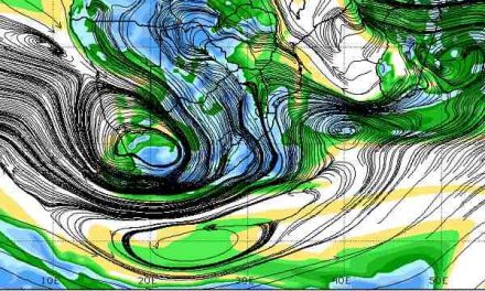
The result was a classic hamburger atmosphere with high pressure control on the surface (airflow from the south), lower pressure conditions in the mid-levels (airflow from the north), and high pressure control in the upper levels (airflow from the east). This unconventional arrangement was marked by a strong zonal flow in the upper levels, but not from the west as usual. This week, due to the low pressure system in the Mozambican Channel, the upper level zonal flow was actually from east to west.
Typically, the upper level influence of the South Atlantic high will quickly push the mid-level trough that develops from Angola, across Namibia and into South Africa, towards the east. This week it did not happen. The airflow from the east opposed the airflow from the Atlantic and the mid-level trough that first appeared on Monday across the Namibian interior, actually shifted towards the west. Widespread but scattered light rainfall was observed in many place across the country, but only west of the line that runs through Katitwe, Grootfontein and Keetmanshoop. The interplay between the high pressure control on the surface and the low pressure trough aloft lead to the somewhat paradoxical observation of cooler nights over the interior, especially from Wednesday onwards, and blistering days over the Botswana border in the east and the Angolan border in the north-east opposite the Kavango Region and Babwatwa.
By the end of the week, the next approaching South Atlantic high pressure cell is still a distance away from the continent. Its outer rim (1016 mB) is only a hundred kilometre or so from Lüderitz and Oranjemund but its core (1024mB) is still some three thousand kilometres into the Atlantic. On the eastern side, the southern Indian high has settled south of Madagascar with a relatively strong core reading 1028 mB. It is slightly displaced to the south.
The surface temperature in the Atlantic is indicated as normal while the Indian Ocean is about 1.5oC warmer than normal. The dynamics of this week between the South Atlantic high and the southern Indian high, coupled with the first low pressure system in the Mozambican Channel, indicate that the general expectation for reduced precipitation can be upset spectacularly over the western half of the sub-continent in that three to four-day window that follows every passing of the South Atlantic high.
What’s Coming
The forecasts are almost unanimous in their view for the next four days. The whole of Botswana and all the territories around it remain blisteringly hot on Saturday with generally low-pressure conditions over the interior. This system shifts towards the east by Sunday as the next South Atlantic high makes landfall. During Sunday night temperatures in the Karas Region will drop considerably leading to a cool Monday and Monday night. The wind will be relatively strong from the south backing to south-east into Monday.
A prominent convergence line develops in its customary position from around Ruacana to Mata Mata on the Botswana border. South west of this line it will be cooler and north-east of it, very hot.
The mid level trough running from Angola across Namibia persists. Strong winds will be experienced over the southern Namib due to the marked pressure differential between the South Atlantic high and the hot interior.