Weather 24 April 2015
![]() What Happened
What Happened
The broad synoptic stance is gradually morphing into an early winter pattern. The daily sunshine hours are now less than twelve hours indicating that the duration of cooling at night is longer than the duration of heating by day. This difference grows by one minute and some seconds every 24-hour cycle.
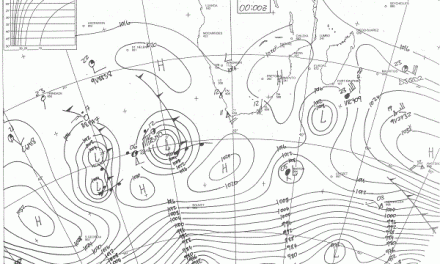
The local weather scene is stuck in a fairly static autumn pattern. From the beginning to the end of this week, the whole country was roughly divided into a western half (smaller) and an eastern half (larger). The dividing line is more or less the 1016 mB line and for most of this week, this imaginary line ran from Eenhana to the Fish River Canyon. West of this line barometric pressure was slightly lower, and east of this line, slightly higher.
To understand this dynamic, one must view the atmosphere above the entire country as one massive, gigantic hamburger. The bottom Broetchen sits on the surface and brings in high pressure control from sea level to about 15,000 feet aloft. Airflow in this level is from the south-west and the south. It brings in colder air and the effect reaches to about Otjiwarongo. The patty is the middle layer and stretches vertically from around 15,000 feet to 30,000 feet. This is the middle layer with a prominent north-eastern to northern airflow. It brings in moisture from Angola and Zambia. The top Broetchen is the upper layer. It stretches roughly from 30,000 feet to 45,000 feet. This week this upper level was also controlled by high pressure but the source is eastern Africa where there is a prominent high pressure presence for the past three weeks.
The only exception to this three-layered atmosphere is the north-western corner covering Kunene and the northern reaches of Erongo. In this triangle, pressures were typically much lower, and will continue to be so during this coming weekend. It is this lower pressure, as it moves southward from Angola to the Orange River, that has the potential to develop into a trough (low pressure band). It is also this low pressure area that creates the generally lower pressures over the western half of the country.
At the beginning of the week, the synoptic map showed the South Atlantic high pressure cell in its customary position south-west of Lüderitz, on its way to move past Cape Agulhas. By Tuesday, the high pressure core lay due south of Agulhas. It quickly split into two cells, the western half remaining over the Atlantic while the eastern half moved to a position south of Madagascar. From there it feeds the high pressure control over eastern Africa, again as earlier this summer, influencing conditions almost to the equator and effectively blocking zonal airflow from the Indian Ocean across the continent. The effect is low moisture over southern Africa, especially Namibia, with only very limited moisture present in the middle layer, i.e. the patty of the hamburger. The result – zero or very little rain.
What’s Coming
High pressure control on the surface, originating from the South Atlantic high pressure cell, remains the order of the day. This effect causes cool nights over the southern half.
The reach of the low pressure area originating in Angola, grows in intensity with the possibility of light showers on Friday, Saturday and Sunday over western Owambo and the whole Kunene region. Depending on the relative strength of the high pressure control in the upper air, this low pressure area may spread south to about Hentiesbaai.
The high pressure control over eastern Africa remains. The pressure differential between high in the east and low in the west, creates a strong north-eastern airflow in the upper levels. This is rather out of the ordinary but as this airflow covers Namibia, it descends, releasing energy, and as it crosses the escarpment, this effect is enhanced, and it could bring strong Oosweer conditions to the northern half of the coastline from around Tuesday onwards.
Overall, most of the country will be subject to high pressure control on the surface but if a trough does develop in the middle layer, it can bring in more clouds than one would expect. However, due to the elevation of the cloud base, there is little prospect of rain.