Weather 17 April 2015
![]() What Happened
What Happened
A noticeable chill has entered the weather stage this week with Otjiwarongo being more or less the latitude where the colder intrusion from the south ends. North of Otjiwarongo daily temperatures reached the lower thirties while south of this line, the middle and upper twenties were more the norm.
In the Karas Region, south of the Lüderitz Keetmanshoop line, night temperatures dropped to around 10oC, with the cold slowly moving to the east. By Thursday morning, Karasburg had its first taste of an early winter.
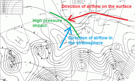
The week’s synoptic progression was fairly typical of a late summer/autumn stance. The week started with the South Atlantic high pressure cell a few hundred kilometres south-west of Lüderitz. By Tuesday it has made landfall, intensifying its grip on the south and manifesting its influence as far north as Otjiwarongo.
The eastern half of the sub-continent was dominated by low pressure conditions, both on the surface and in the middle levels. In Namibia, this lead to a typical western half, eastern half split with a weak trough forming from north (Oshikango) to south (Koes), in the middle levels, visible as a very broad cloud presence but also very shallow.
As the high pressure influence from the south-west grew, the cloud base ascended to about 13,000 feet. This is usually a good indication that general rainfall will not occur, but the tail end of the weak trough ahead of the high pressure cell, lingered over the Aminuis area extending into southern Botswana and South Africa.
The continental anti-cyclonic circulation continued during daytime, bringing a very mild early Oosweer to the coast at the beginning of the week.
However, the most important synoptic feature was the fresh to strong winds experienced at Lüderitz from Tuesday onwards. These winds form during the day when the interior heats up and the barometric pressure drops. With a strong high pressure cell in relative close proximity to the coastline, the pressure differential between high pressure at sea, and low pressure over the interior, leads to Lüderitz’s signature windy conditions. But this is only a feature of the coastal plain and once above the Aus elevation, the winds subside.
As the week progressed, the strong South Atlantic high pressure cell migrated from west to east around the Cape pushing a not-insignificant cold front ahead of it. This was the first week this year for the zero degree Celsius line to come within a hundred kilometres of Port Elizabeth.
By week’s end, the high pressure cell started moving up the eastern side of South Africa while low pressure conditions remained over Mozambique, Zimbabwe, Zambia, the northern half of Botswana and the northern half of Namibia.
What’s Coming
The unknown factor at this stage is how far the high pressure cell from the south will move up the Mozambican channel. If it reaches as far north as Tanzania, it provides a strong push to the continental anti-cyclonic circulation, and although all forecasts indicate zero rain for Namibia next week, there is still a chance of some rain the week after that. But this will entirely depend on the strength and the reach of the eastern high pressure influence.
A large area of low pressure is slowly developing over the central Atlantic, north of the prevailing high pressure cell. This feature needs careful attention as it has the potential to develop into a so-called cut-off low which, if it comes close inshore, may enhance the development of a strong (low pressure) trough from Aiona in southern Angola, all along our western half, and into the southern Namib. If this does happen, late rains may be in store for the western half of the Hardap and Karas Regions.
For this weekend, colder conditions at night in the Karas region, reaching Windhoek, with the wind backing from south to east, bringing also some cooler night temperature to the Kalahari along the Botswana border, as far north as Gobabis. No rain is indicated for next week but watch out for the week thereafter.