Weather 27 March 2015
 What Happened
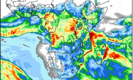
A marked convergence line was present at the beginning of the week running from the Kunene to Aroab. West of this line it was hot and dry while east of it, good cloud formation at about 12,000 feet elevation took place.
With the approaching South Atlantic high pressure cell being relatively weak, the anti-cyclonic circulation over the continent had much opportunity to remain active and extended its reach to the south of Namibia.This was helped along by a well-marked trough (low pressure band) along the convergence line from southern Angola, across Namibia and Botswana, into South Africa.
The southern Namib remained hot and dry as did most of the western half of the Karas region. But further north-east cloud formation took place every day. By Wednesday, the convergence line was still very prominent on satellite images, having shifted only marginally over three days. By Thursday morning, it ran from Swartbooisdrift to Aminuis. Thursday marked the equinox at the Windhoek latitude. Although this day is always indicated for 21 March, it is only at the Tropic, some 25km south of Rehoboth, that it falls exactly on this day. North of this line, the equinox is delayed progressively by some days the further north one goes. What it means for the local weather pattern, is that solar energy will now recede by the day, and the overall weather will begin to reflect a late-summer stance.
Rainfall forecasts are modelled on projections for cloud formation at the 700mB level. This is a mere 8500 feet above sea level. This makes it inappropriate as a forecasting tool for Namibian conditions where the inland plateau lies at an elevation of about 1600 metres or 5500 feet. It is more relevant for local precipitation to look at what is happening at the 500mB level (18,000 feet) or even the 300mB level (30,000 feet). It is all about relative strength and relative elevation.
The weather that developed this week demonstrated this principle excellently. Earlier in the week, the cloud base was low, at around 8000 feet. As the outer rim of the South Atlantic high made landfall, it pushed the cloud base up to 13,000 feet but being rather weak, the moist onslaught from the north-east remained intact. This is what gave us daily cloud formation in the middle levels, i.e. between 15,000 and 30,000 feet. The clouds also showed good structure with visible convection reaching the 45,000 feet level on Tuesday. Indeed very promising clouds. By Friday, the weak South Atlantic high was following its customary trajectory around Cape Agulhas with a marked high pressure influence over southern Namibia. However, the anti-cyclonic low pressure circulation over the central sub-continent remained strong, leading up to a weekend with continued, albeit subdued, expectations for rainfall north and east of the convergence line.
What’s Coming
The warmer water present in the South Atlantic during January and February has now receded to a relatively small area off the coast of Patagonia in South America. By Thursday, this has lead to the formation of two low pressure vortices, one more or less in the middle of the ocean and another closer to South America. This development must be watched since it will have a strong effect on Namibian weather as the low pressure areas approach the African continent during next week. The weekend starts with high pressure control over the southern half of Namibia while the cut-off low of the previous week has morphed into a vortex south of Port Elizabeth in South Africa. Further afield in the southern Indian Ocean, the high pressure cell is in its customary position some 2000 km south-east of Madagascar. This high pressure cell is much stronger than the South Atlantic high pressure cell, leading to enhanced zonal airflow from east to west in the middle levels at around 15,000 feet. This indicates that the conveyor of moisture from the Indian Ocean, across southern Africa into Angola and from there into Namibia, is active and strong.
The (low pressure) vortex behind the South Atlantic high is the synoptic feature to watch. Rainfall prospects over the weekend remain favourable from the Khomas Hochland, across the interior up to Kavango East and the Zambezi. If the approaching vortex develops into a proper cut-off low, heavier falls can be expected next week for almost the entire country. This vortex has the promise of taking moisture from the Kunene River mouth all the way south to the southern Namib.