Weather 27 February 2015
![]() What Happened
What Happened
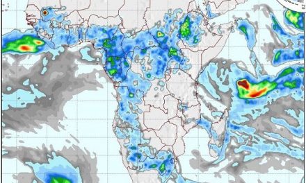
The combination of low pressure and unstable, tropical air produced some spectacular rainfall results this week, showing just what is possible on a localised scale, when conditions are right. An anti-cyclonic low pressure circulation in the upper air above Madagascar, is the main source of moisture with a fairly robust zonal flow from east to west acting as the conveyor to bring this moisture across the continent into southern Angola, and from there into northern Namibia. Yet, the impact of the South Atlantic high pressure cell from the south-west is equally formidable and by Thursday, the system has shifted towards the east taking its promises over the Kavangoes and Bushmanland into the northern corner of Omaheke.The week started with a weak trough (low pressure band) developing in its customary position from Ruacana southeastward across the country to the Kalahari next to the South African border. The core of the South Atlantic high pressure cell lay a few thousand kilometres west of Walvis Bay and the 1016 mB line stretched north to the Kunene River latitude. This again brought colder conditions at night to the south-west, particularly in the Karas Region. But some 2000 km east of Madagascar a tropical depression has developed and continued gaining strength as the week progressed. The onslaught of low pressure from the north-east, and the prominent high pressure cell south of the Orange River, created a well-demarcated convergence line where the two systems meet and interact. It is the tendency of the high pressure cell to control conditions on and close to the surface, while the low pressure area has a more visible impact in the middle and upper layers, that is from around 15,000 feet upwards. This, however, depends to a large extent on local convection which ultimately is the dynamic factor that creates turbulence and rain. By Tuesday the South Atlantic high pressure cell was collapsing as it neared the Namibian coastline. This weakened the push from the south-west allowing so much more space for the (low pressure) trough to form and to penetrate deep into the country east of the convergence line. This resulted in some heavy showers from the Omusati Region in a wide band running through Etosha, Otjiwarongo, Windhoek, Aranos and all the way south to the Kalahari adjacent to the Botswana and South African borders in the south-east. It is a feature of this week’s conditions that general rainfall did not prevail over widespread areas. Instead, it rained heavily but sporadically in patches where the right mix of conditions occurred. The overall synoptic picture showed a west to east split with high pressure control south of the Orange River, and low pressure over the southern African interior. The core of this low pressure area covered eastern Namibia and western Botswana. In the middle layers, air circulation came predominantly from the north-east, again leading to excessively high temperatures in the Hardap Region in the south, and in the Oshikoto Region in the North. This is caused by a combination of Namibia’s topography and the anabatic effect as descending air releases energy due to compression.
What’s Coming
The trough moves gradually towards the east but the interior is still dominated by low pressure conditions. Continental circulation remain anti-cyclonic meaning moisture, albeit in limited amounts is still convected into our airspace in the middle layer between 15,000 and 30,000 feet. This brings cloudy conditions (scattered) during the weekend over the north-eastern half. The south-western half remains clear and cooler. By Monday, a weak trough extends from the Zambezi to the Orange River, this time however, not in the usual north-west south-east (Ruacana Kalahari) orientation, but in a rather anomalous north-east to south-west line. This is the result of high pressure control on the surface over most of eastern Africa. But by Tuesday, the trough has rotated marginally, shifting to a more typical north south orientation, from the Kavango to the southern Cape. This indicates that rainfall potential in the eastern half of Namibia, from the Okavango River to the Orange River, will be more enhanced than in the western half.